The Protected Planet Report 2024 provides the first official review of global progress towards the world's commitment to Target 3 of the Kunming-Montreal Global Biodiversity Framework. This Target aims to safeguard the world’s biodiversity through protected and conserved areas.

The Protected Planet Report 2024 is the first report to fully assess the global status of protected and conserved areas in the context of Target 3 of the Kunming-Montreal Global Biodiversity Framework.

The Protected Planet Report 2024 is the first report to fully assess the global status of protected and conserved areas in the context of Target 3 of the Kunming-Montreal Global Biodiversity Framework. The report brings together the latest official data reported by governments and other stakeholders to the Protected Planet Initiative. 


The aim of Target 3 is to expand the global network of protected and conserved areas to 30% coverage in a way that is equitable and that respects the rights of Indigenous Peoples and local communities. The aim is also to ensure that these areas are effective, well-connected and strategically located in the places that are most important for biodiversity and ecosystem services. 


Each chapter in the report is dedicated to a separate element of Target 3. In this way, the document assesses progress not just towards 30% coverage but also the full scope of other important elements of the target, including towards improving the quality of protected and conserved areas around the world. 


The key findings from the report are:


Overarching

1.     Based on official data, the global coverage of protected and conserved areas has now reached 17.6% of terrestrial and inland waters and 8.4% of marine and coastal areas. While progress has been made in increasing the coverage of protected and conserved areas, this progress must be accelerated considerably if the target is to be fully met by 2030. Acceleration in progress on coverage must be matched by even greater efforts to meet the target’s other elements, which are intended to ensure the quality of systems of protected and conserved areas. Importantly, the expansion of protected and conserved areas must include honoring the target’s commitments to human rights, equitable governance and recognition of Indigenous and traditional territories.


Coverage

2.     Globally, networks of protected and conserved areas are expanding. Since 2020, an additional 629,000 km2 in the terrestrial and inland waters realm and 1.77 million km2 in the marine and coastal realm has been officially protected. While 30% coverage is a global target, there are 51 countries and territories that already have networks of protected and conserved areas that exceed 30% coverage on land and 31 that exceed 30% at sea, highlighting the efforts being made at the national level.


3.     With six years remaining to reach the 30% coverage target in each realm, a further 16.7 million km2 (12.4%) of terrestrial and inland waters, and 78.3 million km2 (21.6%) of marine and coastal areas are needed to be secured in networks of protected and conserved areas. This will require a substantial increase in the rate of expansion of protected and conserved areas seen since 2020.  


Location

4.     Over two thirds of Key Biodiversity Areas (KBAs) are now partially or fully covered by protected and conserved areas. However, the remaining one third (32%) of KBAs fall entirely outside these areas and lack formal protection. This reveals a need for efforts to be increased to better conserve areas of particular importance for biodiversity. 


5.     A quarter of ecoregions already have more than 30% protection.  However, many ecoregions are not currently well represented by the protected area network. Work is needed to ensure systems of protected and conserved areas are ecologically representative. 


6.     Based on an assessment of five global ecosystem services, the majority of areas important for ecosystem functions and services (also known as critical natural assets) are unprotected. Less than one fifth of these critical areas are currently protected.


Connectivity

7.     The global system of protected and conserved areas is not yet well-connected, according to all metrics used in this report. Based upon indicators described in this report, only 8.52% of land is both protected and connected. 


Effectiveness

8.     To date, 177 countries and territories have completed and reported protected area management effectiveness assessments for at least one protected area. However, more data on the quality of governance, management, and the achievement of conservation outcomes are needed to assess and understand progress towards the "effectiveness” aspects of Target 3.


9.     In the marine realm, analysis using the MPA Guide reveals that only 5.7% of the ocean is in marine protected areas that are either implemented (operational with plans for management in place) and/or actively managed. Only 2.8% of the ocean is in fully or highly protected MPAs (i.e., areas where no or only light extractive activities are allowed that have low total impact).


Equitable governance

10.     Data are limited on the extent to which protected and conserved areas are equitably governed. Governance assessments have only been reported for 0.22% of the area covered on land and 0.001% of the area at sea. Such assessments are important for ensuring that Indigenous Peoples and local communities, particularly Indigenous and local women, are engaged in decision-making, have fair access to benefits arising from conservation and are not unfairly impacted by its costs. 


11.     The vast majority of protected and conserved areas are governed by national governments and other state actors. Recognition of non-state governance remains limited, with only 3.95% of the area covered by protected and conserved areas reported as governed by Indigenous Peoples and local communities, and 11.84% under shared governance. 


12.     Beyond protected and conserved areas, Indigenous and traditional territories cover at least 13.6% of global terrestrial areas.


Integrated into the wider landscapes

13.     To ensure the long-term success of biodiversity conservation, protected and conserved areas must be integrated into wider landscapes, seascapes, and the ocean, while promoting sustainable use that is fully consistent with conservation outcomes. This requires a commitment to integrated spatial planning, strong governance and collaborative management, ensuring both biodiversity protection and the enhancement of local livelihoods. 


Fully implementing all aspects of Target 3 is a challenge for all countries. It is one that must be overcome for the sake of all life on Earth.  

"chapter51721"
"CHAPTER"

This decade marks the make-or-break moment for the health of the planet. In December 2022, Parties to the Convention on Biological Diversity reached a historic agreement to halt and reverse the unprecedented loss of biodiversity through the adoption of the Kunming-Montreal Global Biodiversity Framework. It calls upon governments, businesses and society to take urgent action by 2030 to end the biodiversity crisis. 


Two years on, the Protected Planet Report 2024 provides the first official global evaluation of progress towards one of the Framework’s 23 targets – Target 3. This target is best known for the global commitment to protect and conserve 30 per cent of the Earth’s lands and waters by 2030. Importantly, Target 3 goes well beyond coverage. It requires that protected and conserved areas are effectively managed, equitably governed and recognized with respect for the rights of Indigenous Peoples and local communities. It also commits governments to conserve the most important natural spaces and to ensure that these areas are connected to each other. In short, the elements of the target call for in situ conservation to be scaled up in ways that benefit both nature and people. 


Around the world, we are seeing progress. From our vantage point as the directors of IUCN and UNEP-WCMC, it is clear that coverage of protected and conserved areas has increased in all regions in recent years. These results are promising. Indeed, a third of countries and territories have expanded their networks since 2020. While 30% is a global target, there are 51 countries and territories that already have networks of protected and conserved areas that exceed this level of coverage on land and 31 that exceed it at sea. Reassuringly, more than two-thirds of the areas that have been identified as the most important places on Earth for biodiversity are either partially or fully covered by protected and conserved areas. These are positive signs that countries are making headway with identifying and strategically protecting priority areas. 


However, we are still seeing many gaps that are holding the world back from turning the tide. Global coverage has only just passed 17% on land and 8% in the marine realm. More work is needed to scale up coverage and to place protected and conserved areas where they are most needed. This must be done while ensuring that human rights, particularly for Indigenous Peoples and local communities, are respected and upheld.


Simultaneously, there is a pressing need to improve and better track the quality of management, governance and conservation outcomes in protected and conserved areas. Data on these core components of Target 3 are currently minimal, profoundly limiting our ability to discern progress. There are still many ecosystems that are not well represented by conservation networks and a third of the areas most important for biodiversity are not yet protected. 


If we are to succeed in halting and reversing biodiversity loss, the speed of progress must be accelerated. Global ambitions will need to translate into urgent national and local action. All countries around the world will need to contribute in every way that they can.  


It is a huge challenge, but it is not an insurmountable one. The path that we must take is clearly laid out in the Global Biodiversity Framework, and the Protected Planet Report 2024 functions as a status report that candidly tells us where we are on our journey. It is essential reading for all of us striving to support the world to deliver on Target 3. With six years remaining until 2030, the UN Biodiversity Conference (COP16) provides a crucial opportunity for governments to strengthen their actions. Doing so will be essential to meeting the commitments of the Global Biodiversity Framework, including on all aspects of Target 3. We know what is needed. Let us rise to the challenge together and act for nature.  

"chapter51724"
"CHAPTER"

Urgent action is needed at all scales to halt the biodiversity and climate crises. Despite ongoing efforts to protect and restore biodiversity, competing human activities and resulting alterations to the Earth’s natural landscapes and seascapes continue to drive biodiversity loss at rates unprecedented in human history (IPBES 2019; WWF 2024). This poses an enormous threat to both nature and the well-being of people. Humans are dependent on biodiversity for food, materials, and the regulation of all natural systems (Mace, Norris and Fitter 2012; IPBES 2019). Nature can also be a source of significant cultural and spiritual inspiration (e.g., Verschuuren et al. 2021). A transformation is now needed to protect and recognize the value of biodiversity and the vital services it provides.  


In recognition of this, Parties to the Convention on Biological Diversity (CBD) adopted an ambitious plan at the 15th Conference of the Parties: the Kunming-Montreal Global Biodiversity Framework (KMGBF; CBD 2022a). Contained within a package of actions agreed by the Parties, the KMGBF presents four long-term goals and 23 targets for 2030 to halt and reverse biodiversity loss. The Framework emphasizes the need to uphold human rights across all aspects of implementation, including protecting the rights of Indigenous Peoples and local communities. It builds on the former Strategic Plan for Biodiversity 2011-2020, complements the UN Sustainable Development Goals and has important links to the UN Framework Convention on Climate Change and other multilateral environmental agreements. 


The Protected Planet Report 2024 provides the first review of global progress towards one commitment of the KMGBF: Target 3. This Target aims to safeguard the world’s biodiversity in situ through protected and conserved areas. If met, this Target will have determined the ways in which 30% of the world’s surface is managed by 2030.  


In full, Target 3 urges Parties and other governments, with the support of intergovernmental and other organizations, to: 

‘Ensure and enable that by 2030 at least 30 per cent of terrestrial and inland water areas, and of marine and coastal areas, especially areas of particular importance for biodiversity and ecosystem functions and services, are effectively conserved and managed through ecologically representative, well-connected and equitably governed systems of protected areas and other effective area-based conservation measures, recognizing Indigenous and traditional territories, where applicable, and integrated into wider landscapes, seascapes and the ocean, while ensuring that any sustainable use, where appropriate in such areas, is fully consistent with conservation outcomes, recognizing and respecting the rights of indigenous peoples and local communities, including over their traditional territories’
(CBD 2022b).

In comparison to Target 3’s predecessor, Aichi Biodiversity Target 11, Parties to the CBD have greatly scaled up their ambitions for global coverage. On land, the goal has increased from 17% to 30% coverage by protected and conserved areas. In the marine realm, it has increased from 10% to 30%. While this 30% coverage aspect of the target often receives the most attention, all the elements of Target 3 must be achieved for its implementation to be truly successful in delivering conservation outcomes (Figure 1).

Most of these elements focus on the quality of protected and conserved area networks. They include the effectiveness of their management, the prioritization of places where conservation measures are most needed, and the integration of protected and conserved areas into wider landscapes and seascapes.  


Crucially, Target 3 also introduces several new elements that were not present in the wording of Aichi Biodiversity Target 11. Their focus on effective conservation and on providing additional safeguards for people may prove integral to the target’s success. These elements are interpreted in the following ways for this report:


  • Effective conservation: Target 3 supplements Aichi Biodiversity Target 11’s call for effective management by specifying that protected and conserved areas must be “effectively conserved and managed”. While the need for effective management is retained, this shifts the emphasis to also include measurable outcomes for biodiversity.    


  • Equitable governance: Protected and conserved areas must be governed in an equitable manner for local people, meaning the processes underlying management decisions must be just and fair for Indigenous Peoples and local communities, including women and girls. While Aichi Biodiversity Target 11 referred to equitable management, Target 3 explicitly acknowledges that governance (decision-making processes) must be equitable.   


  • Sustainable use consistent with conservation outcomes: Permitted sustainable use of natural resources will often occur in some types of protected and conserved areas. Where such activities do occur, they need to be aligned with conservation outcomes. The explicit acknowledgement that uses of resources, where truly sustainable, will occur within some protected and conserved areas is particularly important for areas that are home to Indigenous Peoples and local communities.  


  • The rights of Indigenous Peoples and local communities1: Acknowledges that Indigenous and traditional territories should be recognized, and that the Target should be implemented with respect for the rights of Indigenous Peoples and local communities. From a human rights perspective, this is an essential aspect of Target 3.


These evolutions from the wording of Aichi Biodiversity Target 11 reflect shifts in perceptions of area-based conservation that have occurred since 2010. While equitable governance, sustainable use and recognition of Indigenous Peoples and local communities have long been included in global standards and guidelines, this has not always translated into practice. Target 3 enshrines them into global policy.  


The Protected Planet Report 2024 presents the first official assessment of the global status of protected and conserved areas in the context of Target 3. Each chapter covers a specific element of the Target (Figure 1) and outlines global progress towards that element based on indicators included in the monitoring framework (CBD 2022b; see Box 1.1 and Methodology). National-level results are also displayed in the report’s figures and in the downloadable results. This breakdown of data, alongside regional findings presented in the Protected Planet 2024 Digital Report, is provided to aid implementation over the next six years. However, it is important to note that Target 3 provides a global ambition that depends on the collective efforts of all countries, and that Parties will define their own national targets as individual contributions towards the global ambition.      


With only six years remaining for the successful implementation of Target 3, this report reveals the extent of progress made to date. It also identifies gaps where renewed and accelerated efforts are needed.  

1 Indigenous Peoples and local communities are considered together within the context of the CBD, under Article 8(j) (Decision V/16, COP 5, 2023) and in the preamble to the Convention (www.cbd.int/doc/legal/cbd-en.pdf), "recognizing the close and traditional dependence of many Indigenous and local communities embodying traditional lifestyles on biological resources, and the desirability of sharing equitably benefits arising from the use of traditional knowledge, innovations and practices relevant to the conservation of biological diversity and the sustainable use of its components". However, it is acknowledged that Indigenous Peoples and local communities have distinct and differentiated rights under international law.

The Kunming-Montreal Global Biodiversity Framework is the first agreement of the CBD to be accompanied by a monitoring framework comprising indicators adopted for use by Parties to assess global progress in a consistent and standardized way. This includes ‘headline indicators’ covering the overall scope of each goal or target, alongside ‘component’ and ‘complementary’ indicators designed to capture and expand understanding of key elements. Where possible, the headline, component, and complementary indicators for Target 3 have been calculated. The report also draws on the revised list of indicators and guidance that will be considered at the UN Biodiversity Conference 2024 (CBD COP16; CBD 2024a; CBD 2024b). For elements where multiple indicators have been adopted, each is presented separately, with insights into the implications of the different results. Detailed information on the indicators used and approach taken can be found in the Methodology. 


Several indicators for Target 3 were adopted within the monitoring framework at COP15 (CBD 2022b). Many of these continue to be refined and will be further negotiated at COP16. For this Protected Planet Report, 18 indicators are presented (Table 1). This includes four analyses not adopted or proposed as Target 3 indicators. These provide further valuable insights into select elements of Target 3 and are marked as “additional indicators”.  

"chapter51734"
"CHAPTER"

To assess global progress towards Target 3, it is essential to understand which area-based conservation measures need to be counted. Target 3 calls for “systems of protected areas and other effective area-based conservation measures” (OECMs) while also “recognizing Indigenous and traditional territories, where applicable” (ITTs; see Chapter 9 for further details). Protected areas and OECMs are referred to collectively as ‘protected and conserved’ areas throughout this report.    


While Target 3 has brought renewed attention to protected areas, they are already a well-established conservation tool that often provides the core of national biodiversity management strategies and policies. Taking many forms, these areas have enabled the conservation of species and habitats for centuries (Brodie et al. 2023; Nowakowski et al. 2023), enhanced ecosystem services (Zeng et al. 2022) and improved the resilience of land and seascapes to climate change (Duncanson et al. 2022; Cannizzo et al. 2023).  

What are protected areas?

Globally, there are two widely accepted definitions of a protected area that are considered equivalent (Lopoukhine and de Souza Dias 2012). The CBD defines a protected area as “a geographically defined area which is designated or regulated and managed to achieve specific conservation objectives”, and the International Union for Conservation of Nature (IUCN) describes a protected area as “a clearly defined geographical space, recognised, dedicated and managed, through legal or other effective means, to achieve the long-term conservation of nature with associated ecosystem services and cultural values” (Dudley and Stolton 2008).

Countries often also have national definitions, policies or legislation that determine what is considered protected. Most formally protected areas are designated legally at the national level. However, the global definitions also encompass areas established through effective, non-legislative means, such as customary law or the policies of non-governmental organizations (NGOs). In addition, areas with characteristics of regional or international importance can also be recognized as protected under multilateral environmental agreements and other intergovernmental processes. These include UNESCO World Heritage sites (areas of cultural and natural heritage considered to be of outstanding value to humanity), Ramsar Wetlands of International Importance and UNESCO Man and the Biosphere Reserves.

 
As a result, what counts as a protected area can be extremely diverse. This diversity is reflected in the names used to describe types of protected area at the national level, which number in the hundreds. However, based on the series of principles that accompany the IUCN definition, “only those areas where the main objective is conserving nature can be considered protected areas; this can include many areas with other goals as well, at the same level, but in the case of conflict, nature conservation will be the priority”. This qualifier helps set these areas aside from other area-based conservation measures.   

 
While protected areas are the main area-based conservation tool formally recognized by governments, other areas can provide important contributions to conservation when effectively managed. In recognition of this, Parties to the CBD introduced a new term in the text of Aichi Biodiversity Target 11 in 2010 – “other effective area-based conservation measures”, or OECMs. 

What are other effective area-based conservation measures (OECMs)?

In 2018, OECMs were formally defined by the Parties to the CBD as: “a geographically defined area other than a Protected Area, which is governed and managed in ways that achieve positive and sustained long-term outcomes for the in-situ conservation of biodiversity, with associated ecosystem functions and services and where applicable, cultural, socio-economic, and other locally relevant values” (CBD Decision 14/8).

Unlike protected areas, where biodiversity conservation must be a primary objective, OECMs might not have biodiversity as their primary objective, but they must have identified ecological values (biodiversity and/or ecosystem functions and services) and deliver long-term, sustained conservation of those values, regardless of their primary focus. To date, OECMs have only been recognized by a handful of countries (e.g., Box 2.1), but they are already making substantial contributions to Target 3 (e.g., see Chapter 3). As OECMs are still a relatively new concept, the recognition of these areas by Parties is an evolving process. Several countries are working to develop or adapt processes and criteria for identification of OECMs. In some cases, these include legal and policy frameworks for the recognition of such sites. However, many countries have not yet started this process. 


Both protected areas and OECMs can vary enormously in the characteristics of their governance and management (Figure 2). The IUCN management category and governance type frameworks, and OECM categories based on objectives, provide a way to group and understand protected and conserved areas across different contexts. A protected area’s management category describes, in broad terms, the approach taken to setting conservation objectives and managing its biodiversity. The governance type (see Chapter 8) indicates who is responsible and accountable for how an area is managed.  


The governance framework includes four governance types for protected areas and OECMs: government, private, Indigenous Peoples and local communities, and shared governance. Many protected areas, and some OECMs, have been reported under the governance of Indigenous Peoples and local communities, albeit in a limited number of countries (see Chapter 8). However, in cases where such an approach may not be appropriate, consideration could be given to recognizing the contribution of Indigenous and traditional territories (ITTs) outside of protected areas and OECMs. The role that Indigenous and traditional territories could play in the implementation of Target 3 is discussed further in Chapter 9.  

To monitor progress towards Target 3, and guide successful implementation by 2030, it is essential to have an accurate and comprehensive picture of the global network of protected areas and OECMs. The World Database on Protected Areas (WDPA) and World Database on Other Effective Area-Based Conservation Measures (WD-OECM), collectively made available via the Protected Planet website, are the largest repositories of information on protected areas and OECMs and provide the official data used to track progress towards various aspects of Target 3. Both databases are components of the Protected Planet Initiative and are managed by the UN Environment Programme World Conservation Monitoring Centre (UNEP-WCMC) as joint products of UNEP and IUCN. 


The data in the WDPA are compiled directly from governments, regional entities, secretariats of intergovernmental agreements and processes, and other stakeholders. Data providers are asked to adhere to the IUCN or the CBD definition of a protected area, or CBD definition of an OECM, and to meet a set of additional data standards. To ensure that the Protected Planet Report 2024 is based on the most up to date information, all CBD Parties were invited to update or contribute new data in 2024. In response, 14,386 records have been added or updated since January 2024. In August alone, 89 countries updated their records (or verified their data to be correct) – representing the largest ever monthly update of the databases. Readers should nevertheless note that very recent designations may not yet be reflected in Protected Planet, and bear this in mind when interpreting the time series results shared here. The findings in this report are based on data provided to the WDPA and WD-OECM as of August 2024 in conjunction with other biodiversity datasets. 

Elizabeth Munro, Jessie Nicholson, Hayley Weeks, Cook Islands National Environment Service


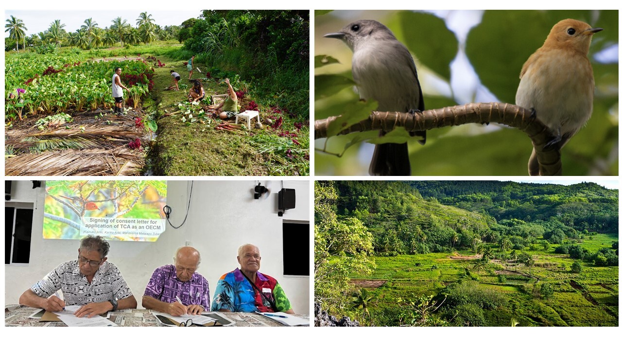
Takitumu Conservation Area (TCA), or Ngai Taporoporo o Takitumu, was declared on 22 May 2024 as the first other effective area-based conservation measure (OECM) in the Cook Islands, and the first designated OECM in Oceania. It covers 1.55 km2 of lowland forest landscape on the Island of Rarotonga.  


Since 1996, TCA has been conserved by three land-owning tribes (Ngāti Kainuku, Ngāti Karika and Ngāti Manavaroa). It is managed to protect the endemic kākerōri bird (Rarotonga flycatcher, Pomarea dimidiata) and to conserve other important, endangered and native species. Management is overseen by the Takitumu Conservation Area Trust, which collaborates with the Cook Islands government, local landowners and the three communities to ensure the long-term protection of biodiversity and sustainable use of resources.  


At a national workshop in 2023, TCA was identified as a potential OECM based on its biodiversity values and the plans set out by the communities to ensure the longevity of these values. A subsequent review process, led by the landowning tribes in collaboration with the Cook Islands government, confirmed that TCA met the OECM criteria. This review included a series of community consultations, and the establishment of a dedicated working group to lead the process. Free, prior and informed consent (FPIC) was obtained and signed by the Ariki (chief) and Mataiapo (sub-chief) of the three tribes to uphold their rights. This also ensured transparency in the recognition process and reporting of data to the WD-OECM.  


To demonstrate and celebrate this success, TCA was awarded a certificate of recognition by the Secretariat of the Pacific Regional Environment Programme (SPREP) and a letter of record for the WD-OECM from UNEP-WCMC. TCA sets a strong example of both collaborative governance and a thorough, inclusive OECM assessment process. 


This OECM was assessed using the IUCN WCPA site-level tool.  


Images top-left and bottom-right: © Cook Islands Tourism. Image bottom left: ©Jessie Nicholson, The Cook Islands National Environment Service. Image top right: Kākerōri birds ©Takitumu Coneservation Area.

"chapter51745"
"CHAPTER"

This chapter presents a summary of the Target 3 headline indicator, “coverage of protected areas and other effective area-based conservation measures”. This relates to the quantitative element of the Target “at least 30 per cent [coverage] of terrestrial and inland waters, and of marine and coastal areas”  by 2030.    


Since 2020, there has been a global increase of 629,262 km2 coverage by protected and conserved areas in the terrestrial and inland waters realm and a 1.77 million km2 increase in the marine and coastal realm. With six years remaining, global progress towards the 30% coverage element of Target 3 is 17.58% of terrestrial and inland waters and 8.44% of marine and coastal areas (Figure 3). 

Globally, 302,934 protected areas and 6,464 OECMs have been reported to the Protected Planet Initiative in total, covering 54.29 million km2 of the Earth’s surface (Figure 4). Most are found in the terrestrial and inland water realms, where 284,242 protected areas cover a total of 22.06 million km2 and 6,253 OECMs cover an additional 1.59 million km2. In the marine realm, there are fewer protected areas (18,692 sites) and OECMs (211 sites) by number, but these sites collectively cover a greater surface area of 30.24 million km2 and 403,605 km2, respectively. This reflects the tendency for larger protected areas to be established in the marine environment, while also highlighting the slower progress towards identifying marine OECMs. At present, 1.12% of marine sites are OECMs compared to 2.15% of terrestrial sites. Although coverage of inland waters is combined with terrestrial areas in these figures, Box 3.1 describes an innovative approach towards understanding inland water coverage specifically. 


To meet the 30% coverage target, a further 16.71 million km2 (12.42%) of terrestrial and inland waters, and 78.26 million km2 (21.56%) of marine and coastal areas need to be established and/or recognized. Importantly, new protected and conserved areas must also be reported to Protected Planet to ensure that they are counted in official assessments of progress. 

The designations employed and the presentation of material on this map do not imply the expression of any opinion whatsoever on the part of the Secretariat of the United Nations concerning the legal status of any country, territory, city or area or of its authorities, or concerning the delimitation of its frontiers or boundaries.


  • Dotted line represents approximately the Line of Control in Jammu and Kashmir agreed upon by India and Pakistan. The final status of Jammu and Kashmir has not yet been agreed upon by the parties.
  • Final boundary between the Republic of Sudan and the Republic of South Sudan has not yet been determined.
  • Final status of the Abyei area is not yet determined.
  • A dispute exists between the Governments of Argentina and the United Kingdom of Great Britain and Northern Ireland concerning sovereignty over the Falkland Islands (Malvinas).

Importantly, Target 3 is a global target. To meet it, countries will need to contribute in different ways. Ambitions for increasing coverage will vary based on countries’ national priorities, biodiversity values and their status, and the available space for protected and conserved areas. The ability of all countries to make meaningful contributions will also be impacted by progress on other KMGBF targets, for example relating to the mobilization of financial resources. While not all countries will be aiming for 30% domestic coverage, many will need to meet or exceed it for the global target to be achieved. Based on data reported to Protected Planet, 35% of countries and territories have expanded their networks of protected and conserved areas since 2020. This means that approximately 65% of countries and territories have either not expanded their networks since 2020 or have not reported updates.


Currently, 51 countries and territories have over 30% coverage by protected and conserved areas in the terrestrial realm, and 31 countries and territories have over 30% coverage in the marine realm (Figure 5). To follow progress after the publication of the Protected Planet Report, readers should consult the national and global coverage statistics that are available and updated monthly at Protected Planet.

The designations employed and the presentation of material on this map do not imply the expression of any opinion whatsoever on the part of the Secretariat of the United Nations concerning the legal status of any country, territory, city or area or of its authorities, or concerning the delimitation of its frontiers or boundaries.


  • Dotted line represents approximately the Line of Control in Jammu and Kashmir agreed upon by India and Pakistan. The final status of Jammu and Kashmir has not yet been agreed upon by the parties.
  • Final boundary between the Republic of Sudan and the Republic of South Sudan has not yet been determined.
  • Final status of the Abyei area is not yet determined.
  • A dispute exists between the Governments of Argentina and the United Kingdom of Great Britain and Northern Ireland concerning sovereignty over the Falkland Islands (Malvinas).

While the number and extent of protected and conserved areas constantly fluctuates as areas are created and expanded or, more rarely, degazetted (stripped of their legal protection) or downsized (see Chapter 7), the overall trend over the past two decades has been one of growth (Figure 6). The previous area target of 17% has now been met, with the time series calculated for this report confirming that this milestone was reached by 2020 (UNEP-WCMC and IUCN 2021). While terrestrial percentage coverage is higher, marine coverage has increased more rapidly, by 650% since 2000. This rate is over 10 times greater than the 62% increase observed in the terrestrial realm during the same time period.

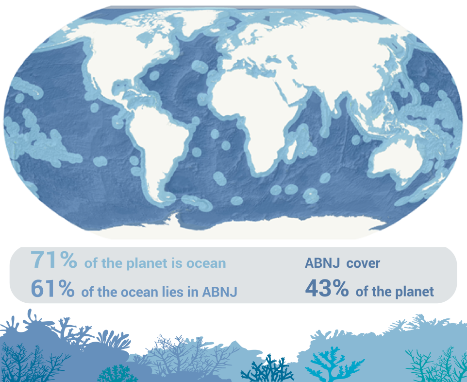
Much of the increase in the marine realm occurred between 2010 and 2020, as countries worked to meet the Aichi Biodiversity Targets. This progress was heavily impacted by the establishment of several large marine protected areas (UNEP-WCMC and IUCN 2021). While growth has remained faster in the marine realm, it has substantially slowed since 2020, likely due in part to delayed reporting. Coverage also remains unevenly distributed, with most marine protected and conserved areas (18,903 sites covering 27.42 million km2) established and reported in areas under national jurisdiction (i.e., territorial seas and Exclusive Economic Zones). In comparison, there are just 10 protected areas (covering 3.22 million km2) in “areas beyond national jurisdiction” (ABNJ, >200 nautical miles from the coast), otherwise known as the high seas. This is despite the latter covering 61% of the ocean. The adoption of the new Biodiversity Beyond National Jurisdiction (BBNJ) Agreement provides an opportunity to address this through the establishment and expansion of the marine protected area network in the high seas (Box 3.2).  


In both terrestrial and marine areas, global increases in coverage are partly due to continued efforts to designate new protected areas. However, the current coverage statistics are also influenced by recent efforts to recognize pre-existing conservation measures that were not previously counted within formal conservation networks (e.g., as OECMs). Although OECMs have only been reported at the global scale since 2019, recognition of these areas is increasing and is already accelerating global progress towards Target 3. OECMs currently contribute 1.18 percentage points of terrestrial coverage. These contributions are significant considering that only 15 countries and territories have reported OECMs to the WD-OECM. As efforts to recognize and report on OECMs proliferate across countries and territories worldwide, it is highly likely that the contribution of OECMs to Target 3 progress will become increasingly significant (see also Jonas et al. 2024).


While the headline indicator captures the core quantitative element of Target 3, increases in coverage alone will not be sufficient for protected and conserved areas to play their part in addressing the biodiversity crisis. Success in achieving Target 3 will also depend on where protected and conserved areas are located and ensuring their quality. The disaggregation of the headline indicator, as proposed for negotiation at COP16 (CBD 2024b; see Chapter 1, Box 1.1), can provide insights into global progress towards several of these quality elements (see Chapters 4, 5, 7, 8). Using additional biodiversity datasets, component indicators and complementary indicators, global progress towards each quality element of Target 3 is addressed in the following chapters. 

Robin Abell, Tara Moberg, Suman Jumani, The Nature Conservancy


For the first time, this Protected Planet Report presents additional statistics on the coverage of inland waters by protected and conserved areas, complementing the combined statistics on coverage of terrestrial and inland water areas. Inland waters – such as wetlands, rivers and streams, lakes, and peatlands – cover a small percentage of the planet but provide essential habitats for biodiversity alongside vital ecosystem services. These ecosystems are under threat. Monitored freshwater species are declining at a higher rate than that found in terrestrial and marine environments, falling by 85% over the past 50 years (WWF 2024). Dedicated reporting on Target 3 progress in inland waters is needed to highlight the current gaps and potential priority areas for future conservation of this important realm.  


Preliminary analyses find that coverage of the inland waters realm by protected and conserved areas is at 16.45% (for wetlands), which is similar to that of the terrestrial realm (16.36% for exclusively terrestrial areas). This suggests that inland waters have neither been intentionally excluded nor intentionally considered in the designation of terrestrial protected and conserved areas. 


The situation is more nuanced, however, at the level of different inland water biomes and ecosystems. This section focuses on rivers, for which standard methods of assessing coverage are insufficient. Globally, 18% of rivers and streams, measured by length, are within protected and conserved areas. This leaves a further 12% required to meet the 30% of Target 3.  When looking across river size classes, there are even starker differences. Almost one third (31%) of the smallest headwater streams are protected or conserved, but all larger classes are less than 18% covered. Less than 1% of the world’s largest rivers are within protected and conserved areas (Figure 7).  This reflects a tendency for protected areas to be disproportionately placed in remote, higher elevation locations that are characterized by headwaters. In contrast, human settlements are concentrated along larger streams and rivers. Although headwater stream coverage is an important success that bears highlighting, the discrepancy with all larger streams and rivers is a reminder that the full implementation of Target 3 will depend upon representative coverage of ecosystems.


Beyond coverage, additional river metrics can be used to assess attributes of effectiveness and connectivity. For example, levels of upstream protection (Abell et al. 2017) and gaps in coverage of free-flowing rivers. Free-flowing rivers are increasingly rare and imperiled and so warrant special attention (Grill et al. 2019), although there has been recent momentum in efforts to restore free-flowing rivers in some parts of the world (e.g., European Commission, Directorate-General for Environment 2022). 


This collection of findings highlights the importance of assessing global coverage of inland waters separately to terrestrial areas. Tracking this is an essential first step towards elevating the importance of inland waters and their protection, though there is room to strengthen reporting and measurement systems in the future. Improvements could encompass finer-resolution measures of ecological and biogeographic representation, more comprehensive assessments of areas of importance for inland water biodiversity and ecosystem services, hydrologically defined measures of connectivity, and measures of management effectiveness that consider external threats transmitted through inland water systems (Moberg et al. in press). While they lack these refinements, the currently available indicators identify a clear need to address the gaps in coverage and representation of inland water systems. 

Irene Llabrés Pohl, UNEP-WCMC 


The year 2023 marked an important milestone for global marine biodiversity policy. With the adoption of a new international and legally binding agreement, governments addressed a longstanding need to coordinate the conservation and sustainable use of marine biodiversity in areas beyond national jurisdiction (ABNJ).2 These remote and largely unexplored regions of the world´s oceans are beyond the control of individual countries. They also make up 61% of marine area or nearly half of the Earth´s surface and are home to unique species and ecosystems (Figure 8). The “Agreement under the United Nations Conventions on the Law of the Sea on the conservation and sustainable use of areas beyond national jurisdiction”, also known as the Biodiversity Beyond National Jurisdiction Agreement or simply the “BBNJ Agreement”, establishes a highly co-operative framework for accessing and safeguarding marine biodiversity in the high seas.  


The BBNJ Agreement provides a pathway towards improving conservation in ABNJ and towards increasing the historically limited coverage of ABNJ by marine protected and conserved areas. Among the various measures to be implemented, a central objective of the Agreement is to establish a comprehensive system of area-based management tools (ABMTs), including ecologically representative and well-connected networks of marine protected areas. These are intended to protect, preserve, restore and maintain biodiversity and ecosystems. It is also expected that they will strengthen the resilience of ecosystems in ABNJ to stressors like climate change, ocean acidification and marine pollution while simultaneously supporting food security and other socioeconomic benefits such as the protection of cultural values.   


As of October 2024, the BBNJ Agreement had 105 signatories and 13 Parties. It will enter into force 120 days after a total of 60 Parties have fully ratified the Agreement. After this, Parties will be able to, individually or collectively, propose marine protected areas and other ABMTs. They will be supported in doing so through scientific guidance and criteria developed by a dedicated Scientific and Technical Body and through consultation with relevant stakeholders. A formal review and public consultation will then inform a decision by the Conference of the Parties on the establishment of new conservation measures.   


The existing low coverage of marine protected areas in ABNJ, as reported in Chapter 3, highlights the immense task ahead. The BBNJ Agreement presents a genuine opportunity to turn the tide. 


2As defined by the United Nations Convention on the Law of the Sea “areas beyond national jurisdiction” refers to all parts of the sea that are not included in an Exclusive Economic Zone, territorial sea, or internal or archipelagic waters of a state (i.e., “high seas”); and the seabed and ocean floor and subsoil thereof, beyond the limits of national jurisdiction (i.e., the “Area”).


Figure 8. The scale of the global oceans and the areas beyond national jurisdiction (ABNJ) within them.

"chapter51772"
"RECOMMENDATIONS"
"chapter51776"
"CHAPTER"

Protected and conserved areas will only be fully effective in addressing biodiversity loss globally if established in the right places. Target 3 emphasizes that protected and conserved areas should especially include “areas of particular importance for biodiversity and ecosystem functions and services” (CBD 2022b). Historically, protected areas have often been established in places where there is no immediate conflict with other human needs (Pressey et al. 2015). Target 3 commits governments to focusing more attention on strategically protecting and conserving the most optimal places for biodiversity and ecosystem functions (CBD 2022b). 

Areas of particular importance for biodiversity

Areas of particular importance for biodiversity can be considered in the context of the KMGBF to be “sites that contain significant populations/extents of threatened or geographically restricted species or ecosystems, or that have significant ecological integrity or irreplaceability, are significant for the maintenance of biological processes, or provide significant ecological connectivity to maintain populations of species” (Plumptre et al. 2024). 


Categories of “areas of importance” include Ecologically and Biologically Sensitive Areas (EBSAs), Important Marine Mammal Areas, and Important Shark and Ray Areas (IUCN WCPA 2024), among others (Jones et al. 2024). Key Biodiversity Areas (KBAs) represent the most comprehensive dataset of areas of importance. KBAs have been identified in all countries worldwide and in terrestrial, freshwater and marine realms. They are “sites contributing significantly to the global persistence of biodiversity” and are identified nationally using globally standardized scientific criteria (described in the Global KBA Standard; IUCN 2016). KBAs aim to bring together the various site-scale approaches to comprehensively identify areas of particular importance for biodiversity, including sites of significance for threatened or geographically restricted species or ecosystems, ecological integrity, biological processes or irreplaceability. These include sites critical for the conservation of the world’s birds, known as Important Bird and Biodiversity Areas (IBAs), the last remaining refuges for Endangered or Critically Endangered species, known as Alliance for Zero Extinction (AZE) sites, and other sites of international significance for the conservation of one or more taxonomic groups in terrestrial, marine, or freshwater systems (IUCN 2016). Data on national KBA networks are brought together in the World Database of KBAs.


The mean percentage coverage of KBAs by protected and conserved areas has been adopted as a component indicator for Target 3 (CBD 2022b) and is a proposed  disaggregation of the headline indicator (CBD 2024a). This aligns with official indicators adopted by the UN for assessing progress towards Sustainable Development Goals 14 (Life Below Water) and 15 (Life on Land), which assess coverage of marine, terrestrial and mountain KBAs by protected and conserved areas (UNGA 2017; UN 2024). 


Globally, over 16,500 KBAs have been identified, covering more than 22 million km2 and representing 4.3% of the world’s surface. Among the 16,227 KBAs with boundaries recorded in the World Database of KBAs, the mean percentage of each individual KBA within protected and conserved areas is 47.72% (including 0.54% by OECMs), an increase of 18.64 per cent since 2000. This means that, on average, approximately half of each KBA is covered by one or more protected area or OECM. The mean percentage of each KBA covered by protected and conserved areas is 48.50% for terrestrial KBAs, 48.16% for freshwater KBAs, and 46.11% for marine KBAs within national waters. While mean coverage of KBAs by protected and conserved areas has substantially improved since 2000, progress has slowed over the past decade (Figure 9). 

In total, approximately two thirds of global KBAs (67.97%) are either fully or partially covered by protected and conserved areas (Figure 10). Just over one fifth (22.02%) of all KBAs are fully covered by protected and conserved areas. The proportion of sites that are completely covered is comparable across the three realms, with 23.29%, 21.88% and 20.16% of freshwater, terrestrial and marine KBAs fully covered by protected and conserved areas, respectively. Across all realms combined, a further 45.95% of KBAs are partially covered. Of these areas, 74 terrestrial, 44 marine, and three freshwater KBAs have partial or full coverage from OECMs, but no coverage from protected areas. Meanwhile, almost one third (32.03%) of KBAs lack protection entirely, with 33.36% of all freshwater KBAs, 30.35% of marine KBAs and 30.04% of terrestrial KBAs remaining fully unprotected.

The designations employed and the presentation of material on this map do not imply the expression of any opinion whatsoever on the part of the Secretariat of the United Nations concerning the legal status of any country, territory, city or area or of its authorities, or concerning the delimitation of its frontiers or boundaries.


  • Dotted line represents approximately the Line of Control in Jammu and Kashmir agreed upon by India and Pakistan. The final status of Jammu and Kashmir has not yet been agreed upon by the parties.
  • Final boundary between the Republic of Sudan and the Republic of South Sudan has not yet been determined.
  • Final status of the Abyei area is not yet determined.
  • A dispute exists between the Governments of Argentina and the United Kingdom of Great Britain and Northern Ireland concerning sovereignty over the Falkland Islands (Malvinas).

Information on areas of particular importance for biodiversity in each country can readily be accessed using the KBA website. The identification of unprotected sites that are important for the global persistence of biodiversity supports countries to plan, prioritize and make decisions on these sites. Prioritizing locations in this way can bolster progress toward Target 3 and the goals of the KMGBF more broadly. In addition, further work is necessary to ensure that national networks of KBAs are as up to date and comprehensive as possible, to ensure that all areas of importance for biodiversity are included and appropriately documented and monitored. Priorities include the further identification of sites important for invertebrates, plants, and less charismatic vertebrate groups, as well as for threatened or geographically restricted ecosystems, and sites of high ecological integrity.


The Species Protection Index (SPI; Map of Life - Indicators; Jetz et al. 2022) is a component indicator for Target 3 that directly and quantitatively addresses the extent to which protected and conserved areas conserve species. The SPI measures the relative importance of all locations worldwide in safeguarding species and delivers detailed global maps of biodiversity importance. For any region, the index measures how well existing protected and conserved areas cover these areas and contribute to species survival. For full SPI results see Chapter 5 in the context of the "ecologically representative" component of the target.

Areas of particular importance for ecosystem functions and services

In the case of ecosystem functions and services, important areas are interpreted for this report as referring to sites critical to human well-being, such as those sequestering and storing carbon, or containing important freshwater sources (Watson et al. 2023).


Historically, the ability to assess coverage of areas important for ecosystem services has been impeded by limited data and methodologies designed to capture and map the benefits people derive from nature (CBD 2024a). As a result, there is currently no agreed indicator in the monitoring framework to assess coverage of these vital areas by protected and conserved areas. However, recent progress has been made to map key ecosystem services, or Nature’s Contributions to People (NCPs), and to identify the areas most important for providing these services – areas that can also be referred to as critical natural assets3 (Chaplin-Kramer et al. 2022). Progress on mapping NCPs and critical natural assets provides an opportunity to further develop a suitable indicator for this element of Target 3 (Dudley and Stolton 2022).


For this Report, four locally relevant NCPs were considered, relating to water quality regulation (two NCPs: sediment retention and nitrogen retention), flood regulation and coastal risk reduction. In addition, vulnerable carbon was included as a global NCP. The analysis looked at both potential NCPs (services that are supplied but not currently used by beneficiaries) and realized NCPs (services that are actively used). “Areas of particular importance for... ecosystem functions and services”, or critical natural assets, were defined for this analysis as those that collectively provide 90% of the NCPs that were assessed. These important areas were found to cover a significant portion of the world’s land. The critical natural assets needed for potential NCPs cover 62.69% of the world’s land surface. For realized NCPs, the figure is 53.38%.


Overlaying these areas with data on protected and conserved areas suggests that just under one fifth of critical natural assets are protected or conserved (19.07% of the total area for potential NCPs and 17.88% for realized NCPs; Figure 11). Since 2020, these figures have increased by 0.41 and 0.28 percentage points, respectively. These findings indicate that most areas important for ecosystem functions and services (critical natural assets) are unprotected and have seen limited improvement since 2020. Covering all critical natural assets through the establishment of protected and conserved areas is clearly unrealistic, but their vast extent highlights the importance of considering Target 3 within the context of the broader Global Biodiversity Framework. Protected and conserved areas will not always be the most suitable tools for maintaining NCPs, particularly those being actively used by local people. Sustainable management is therefore needed across wider landscapes and seascapes if these areas are to continue to support human life and wellbeing. The fact that all critical natural assets cannot be protected within the scope of the 30% target also makes clear the need to prioritize areas that will support the implementation of multiple elements of the target simultaneously. Critical natural assets for which protected and conserved areas are appropriate management tools might often be those with other values that would benefit from conservation, such as areas that also have high biodiversity value or promote connectivity. 

The designations employed and the presentation of material on this map do not imply the expression of any opinion whatsoever on the part of the Secretariat of the United Nations concerning the legal status of any country, territory, city or area or of its authorities, or concerning the delimitation of its frontiers or boundaries.


  • Dotted line represents approximately the Line of Control in Jammu and Kashmir agreed upon by India and Pakistan. The final status of Jammu and Kashmir has not yet been agreed upon by the parties.
  • Final boundary between the Republic of Sudan and the Republic of South Sudan has not yet been determined.
  • Final status of the Abyei area is not yet determined.
  • A dispute exists between the Governments of Argentina and the United Kingdom of Great Britain and Northern Ireland concerning sovereignty over the Falkland Islands (Malvinas).

Global studies suggest prioritizing areas that can contribute to several Target 3 elements is a viable approach, as they demonstrate that many areas of the world are important for both ecosystem services and biodiversity. This suggests that progress on Target 3 could be bolstered by the prioritization of these locations for new protected and conserved areas (Neugarten et al. 2020). Given the intrinsic benefits of such areas to local people, the types of protected and conserved areas needed in these locations will often be those that support sustainable use. In many cases, these will be those with governance led by, or effectively engaging, Indigenous Peoples and local communities. Diverse data, methodologies, and tools are readily available to assist countries in identifying and prioritizing these areas (Dudley and Stolton 2022; Watson et al. 2023). Of equal importance will be the full implementation of KMGBF Target 1 on spatial planning, and Target 10 on sustainability of production systems, ensuring that critical natural assets falling outside protected and conserved areas are still sustainably managed. 

3 Following Chaplin Kramer et al. (2022), Critical Natural Assets were defined in this report as the areas underpinning the supply of 90% of values of either the potential or realized nature’s contributions to people considered in this study.

"chapter51793"
"RECOMMENDATIONS"
"chapter51798"
"CHAPTER"

To protect the diversity of life on Earth, it is necessary to establish systems of protected and conserved areas that cover representative areas for the world’s species, ecosystems, and biogeographic regions. Doing so is important because each biogeographic region4 (ranging from tropical rainforests to arid deserts to freshwater environments and marine regions) differs in the biodiversity it supports and the benefits it provides to people. This is reflected in the wording of Target 3, which calls for systems of protected and conserved areas to be “ecologically representative”. 


To assess this element of Target 3, the coverage of biogeographic regions by protected and conserved areas is proposed as a disaggregation of the headline indicator (CBD 2024a). Here, biogeographic regions are assessed, following the approach proposed in CBD 2024a, at the ecoregion5 level (data sources: Spalding et al. 2007; Abell et al., 2008; Dinerstein et al. 2017) and at the biome6 level using the newly developed IUCN Global Ecosystem Typology7 (Keith et al. 2020). Further insights are provided in Boxes 5.1 and 5.2. 


In total, coverage of 1,528 ecoregions and 23 biomes was assessed across terrestrial, marine, inland water and transitional (overlapping) realms. This approach assumes a 30% coverage target across all biogeographic regions. In reality, the extent of coverage needed for each biogeographic region will depend on many factors, including its relative importance for biodiversity and ecosystem services. Importantly, however, a system of protected and conserved areas with extreme variation in coverage of biogeographic regions (i.e., where some have only low levels of coverage) is unlikely to be fully delivering on the “ecologically representative” aspect of Target 3. Methods that look at both total coverage and how equally biogeographic regions are covered (Chauvenet et al. 2017) may provide useful additional insights on improving ecological representation. 


At present, biogeographic regions are globally unevenly protected. However, a substantial number have already reached 30% coverage. In the terrestrial realm, 233 out of 847 (27.51%) ecoregions are more than 30% covered by protected areas. This number rises by 14 ecoregions with the inclusion of OECMs (taking the proportion of terrestrial ecoregions with 30% coverage to 29.16%). The figures are lower for marine and freshwater ecoregions, where approximately one quarter (57 out of 232, or 25.57%) of marine and one fifth (97 out of 449, or 21.60%) of freshwater ecoregions are 30% covered by protected and conserved areas (Figure 12; Figure 13).


Since 2020, a further six terrestrial ecoregions, two marine ecoregions (Cocos-Keeling/Christmas Island and Western Arabian Sea) and three freshwater ecoregions have met the 30% coverage target. While this is an encouraging finding, 46 (5.43%) terrestrial ecoregions and 42 (18.10%) marine ecoregions still lack any protection (i.e., they have coverage of less than 1%). The picture is, however, slightly more positive in the freshwater realm where most ecoregions are at least partially protected or conserved, with only 13 (2.90%) entirely lacking protection.

The designations employed and the presentation of material on this map do not imply the expression of any opinion whatsoever on the part of the Secretariat of the United Nations concerning the legal status of any country, territory, city or area or of its authorities, or concerning the delimitation of its frontiers or boundaries.


  • Dotted line represents approximately the Line of Control in Jammu and Kashmir agreed upon by India and Pakistan. The final status of Jammu and Kashmir has not yet been agreed upon by the parties.
  • Final boundary between the Republic of Sudan and the Republic of South Sudan has not yet been determined.
  • Final status of the Abyei area is not yet determined.
  • A dispute exists between the Governments of Argentina and the United Kingdom of Great Britain and Northern Ireland concerning sovereignty over the Falkland Islands (Malvinas).

Marine provinces have reached 30% coverage in 14 of 62 (22.58%) cases, and pelagic provinces in only one out of 37 (2.70%). While this is not unexpected given that pelagic provinces are typically very large, the results also highlight the lack of protection in areas beyond national jurisdiction, where pelagic provinces largely occur. There has been no significant improvement in coverage of these provinces since 2020. One notable exception is the Somali Current, a large province of 2.60 million km2, which is now 1.42% covered. 


In terms of biomes, only one of the seven terrestrial biomes meets the 30% coverage target (the tropical-subtropical forests biome). While this is an encouraging finding, the tropical-subtropical forests biome is one where greater than 30% coverage may be warranted given its very high importance for biodiversity and climate regulation (Ometto et al. 2022). The other terrestrial biomes have an average of 15.17% coverage. None of the four marine, three freshwater or nine transitional biomes meets the 30% coverage target, with average coverage of 11.20%, 16.16% and 18.90% respectively.


While progress has been made in some realms, many ecoregions and biomes still lack sufficient (or any) protection. More focus is needed on increasing the representativeness of different biogeographic regions, especially in the open ocean.

In addition to assessing representation of biogeographic regions, it is also important to consider the representation of species diversity. Representing this species diversity within systems of protected and conserved areas is central to several targets of the KMGBF. The Species Protection Index (SPI) is the only component indicator for Target 3 to directly and quantitatively measure how well species are represented within networks of protected and conserved areas (Map of Life - Indicators; Jetz et al. 2022; Powers and Jetz 2019). It can be used to assess both coverage of areas of importance for biodiversity (see Chapter 4) and ecological representativeness. For tens of thousands of species worldwide, the indicator measures the portion of protected or conserved habitat that is suitable in comparison to the total area needed for that species to survive (providing a Species Protection Score, SPS, for each species). The aggregate average of these scores for a region is the SPI. This indicates how well systems of protected and conserved areas capture the total area of suitable habitat required for all assessed species found in a country, region or worldwide.


On land, only half (SPI = 50.13%) of the habitat-suitable ranges necessary to sufficiently safeguard assessed species are covered by protected and conserved areas (for 33,131 assessed terrestrial species). In the marine realm, a higher percentage (SPI = 61.65%) of the required ranges of assessed marine species are within protected or conserved areas (for 12,904 assessed species). Most of this protection is provided by protected areas rather than reported OECMs (the figures are 49.45% and 60.72% without OECMs for the terrestrial and marine realms, respectively). In marine areas beyond national jurisdiction (ABNJ), around one quarter (26.90%) of the total area of habitat-suitable species ranges is covered by protected areas (OECMs do not add to this coverage). However, the habitat-suitable ranges of only 3,302 species occurring within ABNJ were assessed. Since the coverage of protected and conserved areas in ABNJ is, in general, very low, these results should be interpreted with caution. National-level results are shown in Figure 14. 

The designations employed and the presentation of material on this map do not imply the expression of any opinion whatsoever on the part of the Secretariat of the United Nations concerning the legal status of any country, territory, city or area or of its authorities, or concerning the delimitation of its frontiers or boundaries.


  • Dotted line represents approximately the Line of Control in Jammu and Kashmir agreed upon by India and Pakistan. The final status of Jammu and Kashmir has not yet been agreed upon by the parties.
  • Final boundary between the Republic of Sudan and the Republic of South Sudan has not yet been determined.
  • Final status of the Abyei area is not yet determined.
  • A dispute exists between the Governments of Argentina and the United Kingdom of Great Britain and Northern Ireland concerning sovereignty over the Falkland Islands (Malvinas).

4 Area of similar character in terms of the biota (fauna and flora) present in it. Each biogeographic region is based on similarity of composition in terms of the systematics (and hence evolutionary history) of the biota (biogeographical region – European Environment Agency; europa.eu).

5 Ecological units of land, freshwater, or ocean that contain similar and geographically-distinct assemblages of biodiversity (Olson et al. 2001; Spalding et al. 2007; Dinerstein et al. 2017).

Biome as defined in the IUCN Global Ecosystem Typology: A component of a realm (e.g., terrestrial, freshwater, marine) united by broad features of ecosystem structure and one or a few common major ecological drivers that regulate major ecological functions, derived from the top-down subdivision of realms.

7 The IUCN Global Ecosystem Typology includes six hierarchical levels: realms, functional biomes, ecosystem functional groups, biogeographic ecotypes, global ecosystem types, and sub-global ecosystem types. Definitions of each can be found here: https://global-ecosystems.org/.

Marcos Valderrábano and Red List of Ecosystems – Thematic Group in Commission on Ecosystem Management of IUCN


IUCN’s Red List of Ecosystems (RLE) has been adopted as a component indicator of Target 3. While the RLE does not have global coverage, countries with RLE can assess whether protected and conserved areas are providing sufficient coverage to at-risk ecosystems. 


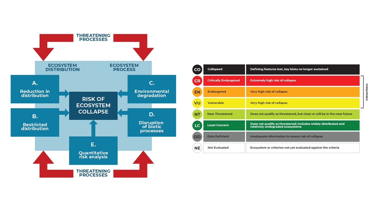
The RLE is an innovative tool for assessing the risk of ecosystem collapse, and the resulting loss of biodiversity. It promotes sustainable environmental management by identifying ecosystem types most at risk and the management pathways that will most effectively reduce those risks. The tool can be applied to any ecosystem across marine, terrestrial and inland water realms. It has been applied to more than 500 ecosystems across more than 100 countries. Mangroves became the first ecosystem to be globally assessed in 2024 (IUCN 2024b).


Red List of Ecosystems assessments are based on the application of five standard criteria, and results are expressed in categories indicating the risk of collapse (Figure 15). The criteria assess: a) changes in ecosystem distribution; b) the restricted distribution of ecosystems; c) the degradation of the abiotic environment; d) the disruption of biotic processes; and e) the probability of ecosystem collapse estimated using a quantitative model.


In the context of protected and conserved areas, the RLE is most frequently used to:


  • Support restoration plans, actions and monitoring
  • Design conservation actions and strategies based on ecological processes critical to ecosystem sustainability or managing the threats that may ultimately cause ecosystem collapse
  • Ensure impact mitigation and compensatory measures including application of the mitigation hierarchy.


For more information, see the IUCN Red List of Ecosystems website.


Figure 15. IUCN Red List of Ecosystems criteria and risk of ecosystem collapse categories.

Simon Ferrier, CSIRO


The Protected Area Representativeness and Connectedness (PARC)-representativeness index developed by CSIRO (Australia’s National Science Agency) measures the degree to which a system of terrestrial protected and conserved areas is "ecologically representative". It does this using mapping of fine-scaled spatial variation in the composition of species assemblages across the entire land surface of the planet, based on modelling that links observations for more than 400,000 species of plants, invertebrates and vertebrates to 1 km-resolution gridded climate, terrain, soil and vegetation attributes. This modelling allows representativeness to be assessed at a much finer and more meaningful ecological resolution than approaches reporting representation only in terms of coverage of relatively broad ecosystem types or biomes. 


The PARC-representativeness value for any specified spatial unit (e.g., a country, a region or the entire planet) is calculated as a geometric mean of the percentage protected of all ecologically distinct environments within that unit. If protection is evenly spread across these environments, then the percentage score obtained for PARC-representativeness will be close to the unit’s overall percentage of protection. However, if protection is biased towards particular environments, leaving other environments and associated species assemblages poorly represented, the PARC-representativeness score for the unit will be lower than the overall percentage protected. The magnitude of this discrepancy indicates the level of ecological bias inherent in the distribution of protection. 


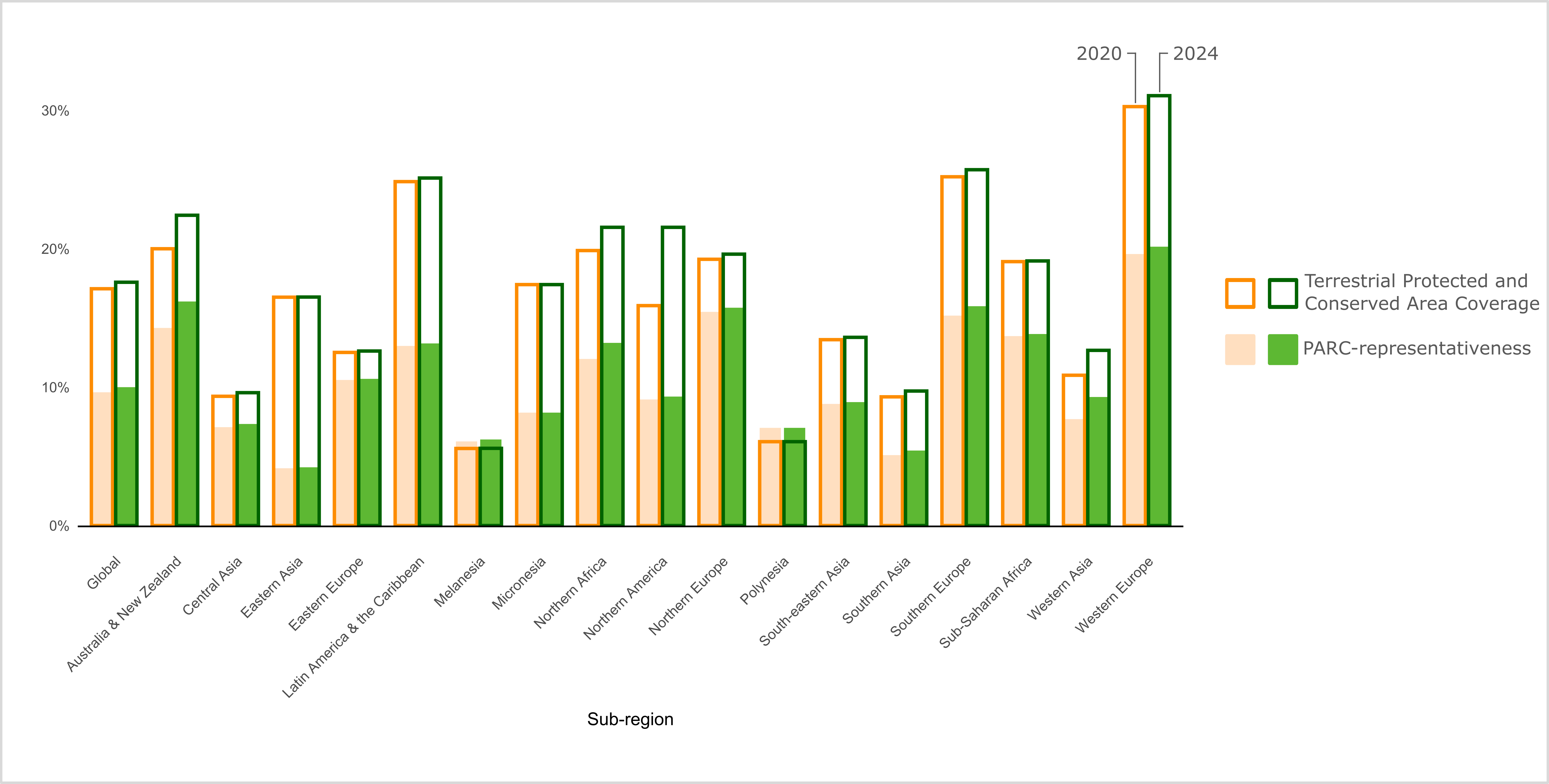
The following chart presents PARC-representativeness results for 2020 and 2024, both at an aggregate global level and disaggregated by subregions, and contrasts these with the overall percentage of protection (by both protected areas and OECMs) for these same spatial units. 


These results indicate that the overall coverage of existing protected areas and OECMs is not evenly spread across fine-scaled environments and their associated species assemblages. This means that coverage is not ecologically representative at these scales. This is particularly apparent at the global level where, for 2024, the mean percentage of the area of ecologically distinct environments protected (10.00%), as reported by the PARC-representativeness index, is only just over half of the percentage of overall land area protected (17.58%). In other words, many of the world’s ecologically distinct terrestrial environments still have less than 10% of their area covered by protected areas and OECMs. Most subregions also exhibit PARC-representativeness values markedly lower than the overall percentage of these subregions protected, most notably for subregions achieving the highest levels of overall protection. 


Figure 16. Mean representativeness score (PARC-representativeness) from 0% (unrepresentative) to 100% (complete and uninterrupted protection of environmental diversity) at the sub-regional level and per cent protected and conserved area coverage between 2020 and 2024.

"chapter51820"
"CHAPTER"

Target 3 calls for “well-connected systems” of protected and conserved areas that are “integrated into the wider landscapes, seascapes, and the ocean” (see Chapter 10). Ecological connectivity can be defined as “the unimpeded movement of species, connection of habitats without hinderance and the flow of natural processes that sustain life on Earth” (CMS 2024). Retaining ecological connectivity is essential to maintaining resilient ecological networks that mitigate drivers of biodiversity loss (Hilty et al. 2019). Individual protected and conserved areas can preserve locations that are important for biodiversity (Chapters 4-5; Watson et al. 2014; Hockings et al. 2019). When linked together in well-connected systems, they can facilitate species movement and migration, while also maintaining overall ecosystem functions. This is increasingly important in the face of climate change. 


Measuring and monitoring connectivity is, however, complex because the ecological processes that underpin it vary enormously across spatial and temporal scales and between environments (Beger et al. 2022). There are two broad approaches to measuring connectivity: structural and functional. Structural connectivity8 reflects the spatial arrangement of habitats and other physical features, while functional connectivity9 goes further by looking at the ease with which organisms can move through land- or seascapes (Tischendorf and Fahrig 2000; Auffret, Plue and Cousins 2015). A well-connected system of protected and conserved areas will be both functionally and structurally connected. However, functional connectivity is substantially harder to measure, particularly over large spatial scales (Keeley, Beier and Jenness 2021). 


There are several metrics available to measure elements of functional and structural connectivity in the terrestrial realm. This includes four indicators that have been adopted within the monitoring framework for Target 3. There are two component indicators, Protected Connected (ProtConn; Saura et al. 2018) and Protected Area Representativeness and Connectedness (PARC)-connectedness (BIP 2024a), and two complementary indicators, Protected Area Isolation Index (PAI; Brennan et al. 2022) and Protected Areas Network metric (ProNet; Theobald et al. 2022). All four indicators focus on the linkages between terrestrial protected and conserved areas. While ProtConn, PARC-connectedness and ProNet focus on physical habitat links, the PAI also incorporates aspects of functional connectivity. It is important to note that measures of connectivity are not currently available for inland waters or the marine realm. 

ProtConn estimates the degree to which protected and conserved areas are linked, providing a straightforward indicator of structural connectivity that can be used at local to global scales. It reflects the percentage of the landscape that is both protected and structurally connected, increasing as more land becomes reachable through connections among protected and conserved areas (Saura et al. 2018; BIP 2024b).


ProtConn indicates that 8.52% of the world’s terrestrial surface is protected and connected. This is an improvement on the figure of 7.84% reported in the previous Protected Planet Report (UNEP-WCMC and IUCN 2021), but still indicates that a further 21.48% is needed to reach Target 3 by 2030. OECMs add to the global ProtConn score, with the proportion of the world’s terrestrial surface protected and connected reducing to 7.54% when OECMs are not considered.  

The designations employed and the presentation of material on this map do not imply the expression of any opinion whatsoever on the part of the Secretariat of the United Nations concerning the legal status of any country, territory, city or area or of its authorities, or concerning the delimitation of its frontiers or boundaries.


  • Dotted line represents approximately the Line of Control in Jammu and Kashmir agreed upon by India and Pakistan. The final status of Jammu and Kashmir has not yet been agreed upon by the parties.
  • Final boundary between the Republic of Sudan and the Republic of South Sudan has not yet been determined.
  • Final status of the Abyei area is not yet determined.
  • A dispute exists between the Governments of Argentina and the United Kingdom of Great Britain and Northern Ireland concerning sovereignty over the Falkland Islands (Malvinas).

The ProNet metric measures the structural connectivity of a protected and conserved area system. It is not sensitive to the surrounding environment, but instead is solely based on whether an individual protected or conserved area is located within 10 km of another area. ProNet provides values from 0 (unconnected) to 1 (fully connected; Theobald et al. 2022). 


The global connectivity score for protected and conserved areas based on ProNet is 0.29. This indicates that 28.90% of protected and conserved areas are connected but that most (71.10%) are not. When only connectivity between protected areas was considered, the global ProNet value decreased slightly to 0.26 (or 25.6% connected), meaning OECMs account for 3.30% of global connectivity. At the national level, 11 countries and territories with terrestrial protected and conserved area coverage greater than 30% were also highly connected (ProNet > 0.99).  

The designations employed and the presentation of material on this map do not imply the expression of any opinion whatsoever on the part of the Secretariat of the United Nations concerning the legal status of any country, territory, city or area or of its authorities, or concerning the delimitation of its frontiers or boundaries.


  • Dotted line represents approximately the Line of Control in Jammu and Kashmir agreed upon by India and Pakistan. The final status of Jammu and Kashmir has not yet been agreed upon by the parties.
  • Final boundary between the Republic of Sudan and the Republic of South Sudan has not yet been determined.
  • Final status of the Abyei area is not yet determined.
  • A dispute exists between the Governments of Argentina and the United Kingdom of Great Britain and Northern Ireland concerning sovereignty over the Falkland Islands (Malvinas).

PARC-connectedness assesses the extent to which protected and conserved areas are connected, not only to one another but also to unprotected areas of intact natural vegetation. When PARC-connectedness values are high, this suggests greater levels of integration into the wider landscape. PARC-connectedness also incorporates remotely-sensed data on land cover change that makes it possible to track the loss of connectivity that occurs when unprotected intact vegetation is lost (BIP 2024a). This indicator provides a connectivity score from zero (unconnected) to 1 (continuous and uninterrupted connectivity).


The global PARC-connectedness score is 0.71 (0.69 with protected areas only, rising by 0.01 with OECMs). This indicates that, on average, each grid cell (1 km2) on land within a protected or conserved area is 71% connected to grid cells containing intact natural vegetation and/or other protected or conserved grid cells. Therefore, locations within protected and conserved areas are somewhat well-connected to intact areas within broader ecological networks or to other locations within protected and conserved areas themselves. However, connectivity gaps remain that need to be addressed. Importantly, the areas of intact natural vegetation that contribute to this score are not necessarily protected themselves. Ensuring the sustainable management of these areas is necessary to ensure they continue to facilitate connectivity within systems of protected and conserved areas into the future. Since 2020, the average global PARC-connectedness score has increased marginally by 0.20 percentage points.

The designations employed and the presentation of material on this map do not imply the expression of any opinion whatsoever on the part of the Secretariat of the United Nations concerning the legal status of any country, territory, city or area or of its authorities, or concerning the delimitation of its frontiers or boundaries.


  • Dotted line represents approximately the Line of Control in Jammu and Kashmir agreed upon by India and Pakistan. The final status of Jammu and Kashmir has not yet been agreed upon by the parties.
  • Final boundary between the Republic of Sudan and the Republic of South Sudan has not yet been determined.
  • Final status of the Abyei area is not yet determined.
  • A dispute exists between the Governments of Argentina and the United Kingdom of Great Britain and Northern Ireland concerning sovereignty over the Falkland Islands (Malvinas).

The Protected Area Isolation Index (PAI) indicates functional connectivity of terrestrial protected areas, measuring their degree of isolation from the viewpoint of moving mammals (Brennan et al. 2022; WWF 2022). It accounts for human pressures and their impact on animal movement (Brennan et al. 2022).


PAI does not provide a global-level indicator of connectivity. Instead, it provides scores at the national or subregional level that are then used to compare relative levels of connectivity. According to PAI, Greenland, Brunei, Guyana, Canada and French Guiana are the countries and territories with the most connected protected and conserved area networks (Figure 20). On a sub-regional level, Australia-New Zealand is the sub-region with the most connected network. Western Europe has the least connected protected area network.

The designations employed and the presentation of material on this map do not imply the expression of any opinion whatsoever on the part of the Secretariat of the United Nations concerning the legal status of any country, territory, city or area or of its authorities, or concerning the delimitation of its frontiers or boundaries.


  • Dotted line represents approximately the Line of Control in Jammu and Kashmir agreed upon by India and Pakistan. The final status of Jammu and Kashmir has not yet been agreed upon by the parties.
  • Final boundary between the Republic of Sudan and the Republic of South Sudan has not yet been determined.
  • Final status of the Abyei area is not yet determined.
  • A dispute exists between the Governments of Argentina and the United Kingdom of Great Britain and Northern Ireland concerning sovereignty over the Falkland Islands (Malvinas).

While the four indicators presented here use different methods, measure different facets of connectivity, and produce different results, they converge on one key message: The world’s network of protected and conserved areas is not well connected yet. The indicators reveal that the current terrestrial coverage of 17.58% does not equate to 17.58% of the world’s land being within well-connected systems of protected and conserved areas. This is an important reminder that achieving 30% coverage by 2030 alone will not deliver on Target 3. Efforts to expand protection must also address connectivity. An example of practical action being taken is provided in Box 6.2.  


Furthermore, understanding and monitoring connectivity in the marine realm remains problematic. At present, the four indicators are limited to the terrestrial realm, although work is ongoing to adapt some of them to the marine realm. Measuring connectivity becomes increasingly complicated in flowing water systems. The challenge stems from the fact that these systems require additional consideration of vertical linkages in water columns, longitudinal linkages (e.g., between up and downstream waters), lateral linkages (e.g., between river channels and floodplains), and ‘inter-realm’ linkages between freshwater, marine and terrestrial spaces (e.g., O’Leary and Roberts 2018; Grill et al. 2019; Braun et al. 2023). While complex to analyse, all these connections provide important contributions to the maintenance of species, populations, ecological functions and healthy ecosystems.  


8 Structural connectivity for species: A measure of habitat permeability based on the physical features and arrangements of patches, disturbances and other land, freshwater or seascape elements presumed to be important for organisms to move through their environment. Structural connectivity is used in efforts to restore or estimate functional connectivity where measures of it are lacking (Hilty et al., 2019).

9 Functional connectivity for species: A description of how well genes, gametes, propagules or individuals move through land, freshwater and seascape (Rudnick et al. 2012; Weeks 2017).

Aaron Laur and Gabriel Oppler, Center for Large Landscape Conservation


Ecological connectivity is a key element of the Kunming-Montreal Global Biodiversity Framework, not just in the context of achieving Target 3 but also for Goal A and Targets 1, 2, 12 and 14.


In efforts to meet, exceed, and secure national commitments under the KMGBF, countries around the world are increasingly prioritizing ecological connectivity and applying ecological corridor and network approaches across ecosystems that are key to:


  • Preserving remaining intact and connected natural areas,
  • Arresting and reducing fragmentation,
  • Restoring lost or degraded interconnections,
  • Reversing rates of biodiversity loss, and 
  • Increasing resilience to climate change.


This is evident in a recent review and compilation of information from submitted revised or updated NBSAPs detailing at least 15 countries using the terms “ecological connectivity”, “ecological corridors”, or “ecological networks”, and/or specific objectives for maintaining, enhancing, and restoring connectivity, including through the avoidance and mitigation of impacts from linear infrastructure.


The KMGBF monitoring framework includes a number of indicators for connectivity. To support aspects of the related planning and reporting requirements, practical guidance has been produced to enhance understanding of what each of these indicators measures, the resources necessary, and the usability and applicability to the various contexts. This is especially essential for ongoing national target setting, and baseline understanding, implementation, and adaptive management over time. 


Specific to “ecological corridors”, the first-ever World Database on Ecological Corridors (WDEC) is currently being pilot tested with what is hoped will be a growing number of CBD Parties. The WDEC is a spatial database that collects information on where ecological corridors are located globally and how those corridors are structured, governed, and managed. Once operational, the WDEC will complement the World Database on Protected Areas (WDPA) and World Database on Other Effective Area-based Conservation Measures (WD-OECM) to provide a more holistic picture of area-based conservation networks around the world.

Rafael Antelo, Wildlife Connect Initiative Lead, Annika Keeley, Senior Conservation Scientist, Center for Large Landscape Conservation


Wildlife Connect is a joint initiative between WWF, the Center for Large Landscape Conservation (CLLC), the Convention on Migratory Species (CMS) and the IUCN WCPA Connectivity Conservation Specialist Group (CCSG) that aims to maintain or increase the ecological connectivity of landscapes. This global initiative focuses on a representative subset of landscapes in Africa, Asia, Europe, and South America. This box showcases Wildlife Connect efforts in South American and African landscapes.


In South America, Wildlife Connect, with the support of WWF, works towards conserving the jaguar’s ecological network in the Pantanal Chaco landscape. A team of 30 jaguar and connectivity experts from Argentina, Bolivia (Plurinational State of), Brazil and Paraguay, with the technical support of CLLC, identified the jaguar's ecological network through a participatory process. This network includes the core sites for the conservation of the species and the corridors that connect them. These corridors are now priority sites for implementing conservation actions that benefit both jaguar conservation and local and Indigenous populations. These actions include monitoring jaguar populations, strengthening Indigenous women's livelihoods, promoting jaguar-livestock coexistence and law enforcement, among others. Involvement of national and subnational governments in the initiative is planned for 2025. More information is available at: América Latina - Wildlife Connect Powered by WWF.


The work of Wildlife Connect in Africa focuses on assessing the functionality of ecological corridors, in addition to monitoring and supporting their implementation for the conservation of focal species, in the Southern Kenya Northern Tanzania landscape. In an effort led by WWF and CLLC, 73 specialists on elephants, wildebeest, cheetahs, African wild dogs, lions, giraffes, and zebras from the two countries agreed to jointly build the Transboundary Corridors and Connectivity Atlas for the landscape. These partners will collaborate to assess the functionality of the ecological corridors already identified in this landscape for the focal species, create a database with spatial information on the corridors, develop a comprehensive baseline assessment of the corridors using a set of indicators as a basis for annual monitoring, and share enabling conditions necessary for the implementation of transboundary corridors. The first meeting of the initiative in Africa included representatives from the Kenya Wildlife Research and Training Institute and the Tanzania Wildlife Research Institute, involving these government organizations in the initiative. More information is available at: África - Wildlife Connect Powered by WWF.

"chapter51854"
"CHAPTER"

The previous sections of this report focused on the important progress made towards expanding systems of protected and conserved areas. However, the impact of protected and conserved areas depends not only on where they are placed, but also how they are conserved and managed (Coad et al. 2019; Arneth et al. 2023). This is clearly reflected in the language of Target 3, which highlights the need to ensure that 30% of terrestrial and inland water areas, and of marine and coastal areas are “effectively conserved and managed”


At its most basic level, effectiveness depends upon protected and conserved areas successfully conserving the biodiversity values for which they were recognized. Target 3 also aligns success closely with governance and management that maintains or enhances social values such as equity (see Chapter 8) and human rights. Effective protected areas have progressed beyond the designation stage to having appropriate governance and management processes in place and are appropriately designed in terms of location, size and configuration. Effectiveness also depends upon these areas retaining their protection status over the long-term. Once these conditions are in place, a range of other factors that influence effectiveness come into play. These include sufficient funding (Lessman et al. 2024), sufficient personnel (Appleton et al. 2022), sufficient levels of protection (Grorud-Colvert et al. 2021) and good governance (including equitable engagement of rightsholders and stakeholders; Maxwell et al. 2020; Gurney et al. 2023). Evidence shows that protected areas having positive outcomes for both nature (Maxwell et al. 2020) and people (Gill et al. 2017; Naidoo et al. 2019) depends on them being well-managed, well-designed and well-resourced. Effective protected and conserved areas have clear biodiversity goals and a monitoring system to determine if those goals are being met.


Assessing the effectiveness of protected and conserved areas at the site, system and global level is challenging. This is due to a complex interplay of factors including the design and location of the areas and their place in the wider system of conservation measures. Effectiveness is contingent upon many factors including whether a system is well connected and ecologically representative and whether the processes used to manage the sites within it are appropriate (Rodrigues and Cazalis 2020). Management effectiveness assessments are often used to understand the quality of management at site level. Information on these assessments is compiled in the Global Database on Protected Area Management Effectiveness (GD-PAME), which provides a component indicator (and proposed disaggregation of the headline indicator) for Target 3. The indicator currently assesses the coverage of protected and conserved areas that have been assessed, with a more sophisticated and insightful approach under development (see Box 7.1). 


The GD-PAME contains assessment records for 177 countries conducted using 75 methodologies. In total, 6.8% of protected areas in the WDPA have been assessed (28,969 assessments for 20,603 protected areas). When combined with spatial data from the WDPA, these data show that 4.78% of the world’s terrestrial area is covered by protected areas where management effectiveness has been assessed. The figure is 1.26% for the marine realm. No effectiveness data are currently reported for OECMs, although international guidance recommends the application of PAME tools alongside quantitative information on biodiversity outcomes to monitor these areas, and for this to be reported to the GD-PAME (IUCN-WCPA Task Force on OECMs 2019). These results show that much more focus is needed on management effectiveness, both in terms of conducting assessments and reporting data at the global level. Since many assessments are considerably outdated, there is also a need to ensure that effectiveness is monitored, and reported on, at appropriate time intervals.

The designations employed and the presentation of material on this map do not imply the expression of any opinion whatsoever on the part of the Secretariat of the United Nations concerning the legal status of any country, territory, city or area or of its authorities, or concerning the delimitation of its frontiers or boundaries.


  • Dotted line represents approximately the Line of Control in Jammu and Kashmir agreed upon by India and Pakistan. The final status of Jammu and Kashmir has not yet been agreed upon by the parties.
  • Final boundary between the Republic of Sudan and the Republic of South Sudan has not yet been determined.
  • Final status of the Abyei area is not yet determined.
  • A dispute exists between the Governments of Argentina and the United Kingdom of Great Britain and Northern Ireland concerning sovereignty over the Falkland Islands (Malvinas).

Although PAME assessments have been commonly used (Hockings, Stolton and Leverington 2006), they do not always sufficiently capture the links between management inputs and processes and the achievement of conservation outcomes (Maxwell et al. 2020). In part, the IUCN Green List Standard was developed out of a recognition of this shortcoming (Hockings et al. 2019). Widely acknowledged as the most comprehensive standard for effective area-based conservation, it consists of three core components: good governance, sound design and planning and effective management. These components act as stepping-stones towards the fourth component of successful conservation outcomes. The Standard provides a global benchmark for effective area-based conservation (i.e., providing guidance on what should be assessed to understand progress towards effectiveness). It is complemented by a list of protected and conserved areas certified by IUCN against the Standard. The number of Green Listed sites is a complementary indicator for Target 3. There are now 87 such sites across 18 countries.  


Building on both the GD-PAME and Green List Standard, a system is under development to enable reporting of detailed data on all elements of effectiveness. In the run-up to 2030, this system will provide the basis for an evolution of the current indicator based on the GD-PAME. The expected outcome is a more meaningful disaggregation of the headline indicator, showing coverage of protected and conserved areas grouped by levels of effectiveness (Box 7.1; IUCN WCPA 2024). 


In addition to active management and monitoring (Box 7.2), the effectiveness of protected and conserved areas depends upon sustained, long-term commitment to conservation in these areas. Tracking legal changes to protected and conserved areas provides a complementary approach to understanding effectiveness by highlighting socio-political changes that may affect the status of an area and therefore its ability to conserve biodiversity. Protected area downgrading, downsizing and degazettement (PADDD) is a phenomenon describing legal changes that ease a protected area’s restrictions (downgrading), reduce its size (downsizing), or result in its elimination (degazettement; Golden Kroner et al. 2019). Depending on the context, these changes may have a significant impact on the protected area’s capacity to conserve biodiversity (Golden Kroner et al. 2019), for example, by accelerating forest loss and carbon emissions (Forrest et al. 2015). PADDD is a complementary indicator for Target 3, and an analysis of PADDD events is included in this Protected Planet Report for the first time.


Since 2009, civil society organizations and researchers have been tracking PADDD events, including proposed and enacted changes, in state-governed protected areas (privately protected areas; territories and areas governed Indigenous Peoples or local community communities; protected areas recognized by international entities and OECMs are not included in the analysis) (Mascia et al. 2020; Conservation International and WWF 2021). Information on PADDD is compiled using a range of sources including, among others, the WDPA, official legal documents, peer reviewed journal articles and grey literature. 


An analysis of PADDD events tracked by the initiative found a total of 2,173 enacted downgrades (affecting 1,832 protected areas), 604 instances of enacted protected area downsizing (affecting 470 protected areas) and 328 enacted degazettement events (affecting 325 protected areas) to have occurred between 1895-2021 (Figure 22). The absolute total area affected by enacted events (which removes overlapping PADDD events) is 2.68 million km2, while the enduring total area affected (removing enacted PADDD events that were subsequently reversed) is 2.14 million km2. These figures demonstrate the impermanence of many protected areas, and their susceptibility to broader socio-economic and political changes, despite their intended goal (according to international standards) of conserving biodiversity for perpetuity. This highlights the importance of long-term resourcing and political commitment alongside appropriate management, equitable governance, sound design and planning to ensure that these areas can be effective in achieving their intended purpose to conserve biodiversity. Ongoing monitoring, research, and support are required to continue tracking PADDD events, understand their impacts, and enable interventions to support long-term conservation.

Helen Klimmek, UNEP-WCMC


UNEP-WCMC and IUCN, including WCPA, are developing an approach to enhance reporting and improve global understanding of effective area-based conservation (IUCN WCPA 2024). The current system of reporting to GD-PAME provides data on whether protected and conserved areas have been assessed. The system in development will allow for more detailed reporting on the results of those assessments.


GD-PAME and existing methods for assessing effectiveness (e.g., PAME tools, governance assessment tools and the IUCN Green List Standard) will form the basis of this system. Recognizing that some countries have well-established mechanisms for monitoring effectiveness in place, the system will encourage data providers to use results from existing assessment tools to report and benchmark progress towards good governance, sound design and planning, effective management and successful conservation outcomes.


Further refinement and testing of the proposed reporting system is planned to ensure feasibility. Ultimately, the system will enable future assessments of progress towards Target 3 to include a breakdown of protected and conserved areas by level of effectiveness, including whether they are delivering positive outcomes for biodiversity.

Jenna Sullivan-Stack and Kirsten Grorud-Colvert, Oregon State University in collaboration with Marine Conservation Institute’s MPAtlas


The MPA Guide helps determine if an area in the ocean is effectively conserved and managed. Some Marine Protected Areas (MPAs) have plans in place for management, whereas others exist only “on paper”, in laws or regulations that have not yet been implemented. In addition, some MPAs have many types of destructive activities occurring inside them. This may even occur when regulations are meant to mitigate these harmful practices. Other MPAs are fully or highly protected against these impacts. 


The MPA Guide provides a common language to describe different types of MPAs according to these features. It predicts the biodiversity outcomes that can be expected from any given MPA.  Use of The MPA Guide complements other tools for understanding MPAs. For example, The MPA Guide can be used together with assessments of site-level management effectiveness, which are helpful for determining whether an MPA is broadly successful at achieving its management goals, even beyond biodiversity conservation. The MPA Guide also complements the IUCN Protected Area Management Categories, which highlight the intent of an area based on its management objectives. 


Approximately 90% of the total global area in MPAs reported to the WDPA has been assessed using the MPA Guide as of August 2024 (peer reviewed numbers in Sullivan-Stack et al. 2024, representing >1,000 MPA zones; shared at mpatlas.org). Assessments have been undertaken by ocean experts around the world to predict the outcomes of MPAs in their country, region or local area. These assessments document that, of the 8.4% of the global ocean covered by MPAs of any kind, 69% of this area is actively managed, but 21% is not yet implemented (Figure 23).  It also shows that, of the 69% being actively managed, 49% is fully and highly protected. Yet, in 50% of the area, there are high-impact activities happening that are extractive and destructive. Biodiversity conservation benefits from some of these MPAs are expected to be minimal or non-existent (Figure 23). Overall, these data show that although 8.4% of the ocean is in MPAs, 5.7% of the ocean is in MPAs that are active (either implemented and/or actively managed), and only 2.8% of the ocean is in fully or highly protected MPAs.


The accumulation of MPA Guide information at a global scale provides a consistent indicator for the biodiversity conservation outcomes that can be expected from the current system of MPAs. This clarity highlights areas for investment to improve existing MPAs and demonstrates a need to establish new MPAs that are expected to conserve biodiversity and its benefits for human well-being. 


The MPA Guide is facilitated by its founding partners: IUCN, UNEP-WCMC, National Geographic Pristine Seas, Marine Conservation Institute’s Marine Protection Atlas, and The MPA Project at Oregon State University.  

"chapter51870"
"CHAPTER"

Target 3 emphasizes the importance of fair, just governance, specifying that areas must be “effectively conserved and managed through… equitably governed systems of protected areas and OECMs... recognizing and respecting the rights of indigenous peoples and local communities”. In the context of protected and conserved areas, governance relates to who is making management decisions and how those decisions are made (Borrini-Feyerabend et al. 2013). How governance involves, recognizes, impacts and benefits Indigenous Peoples, local communities and other relevant actors determines whether it can be considered equitable.


Over the past 20 years, there has been an increased emphasis on equitable governance and rights in area-based conservation. This is reflected by efforts to enhance the quality of governance and address cases of inequity or injustice (Franks, Small and Booker 2018). These efforts are crucial for ensuring that area-based conservation measures uphold the rights of rightsholders and stakeholders, engage Indigenous Peoples and local communities, and support human well-being as well as nature (Franks, Small and Booker 2018). Importantly, measures are needed to champion women’s effective participation and leadership in governance (e.g., Gissi et al. 2018). The role of equitable governance in achieving effective conservation is also increasingly being recognized, with strengthened governance leading to the delivery of more positive ecological and biodiversity outcomes (Oldekop et al. 2016; Fidler et al. 2022; Pinto and Dawson 2023; Zhang et al. 2023; Dawson et al. 2024). 


Equitable governance encapsulates three key dimensions: 


  1. Recognition: Acknowledgement and respect for a diversity of actors, as well as their rights, values and knowledge systems.  
  2. Procedure: Inclusive, participatory and transparent decision-making and conflict resolution.
  3. Distribution: The equitable sharing of all costs and benefits (CBD 2018c). 


The understanding of equitable governance continues to evolve, with increasing focus on understanding the social, political and economic enabling conditions that can advance these three key dimensions of equity in protected and conserved areas. These conditions include national policies and the balance of power between different actors (Figure 24; Franks et al. 2024).


To assess the "equitably governed" element of Target 3, two indicators (Box 8.1) have been adopted by Parties to the CBD: one indicating the quality of governance (component indicator) and the other assessing the diversity of governance types (complementary indicator). Both indicators are also proposed disaggregations of the headline indicator (where quality of governance is captured within the proposed disaggregation by level of effectiveness) (CBD 2024a; see Chapter 1, Box 1.1).

Quality of Governance

Various tools have been developed to allow stakeholders and/or rightsholders to assess the quality of governance at the site level. The Site-level Assessment for Governance and Equity (SAGE) is a currently applied tool that has been proposed as the component indicator for monitoring progress towards the equitable governance element of Target 3 (CBD 2022b). The indicator looks at the number of protected areas that have completed a SAGE assessment. Developed by the International Institute for Environment and Development (IIED), SAGE facilitates self-assessment of the social impacts and equity of conservation action (Franks 2023). SAGE provides an extensive and detailed assessment of the quality and equity of governance, aligned with the three key dimensions of equity (CBD 2018c). A recent meta-analysis in the results of SAGE assessments found that areas governed by Indigenous Peoples and local communities tended to have higher levels of equity than those governed by government agencies (Dehmel et al. in press). An essential element of SAGE and other assessments of governance quality is the identification of weaknesses, opportunities and actions needed for improving the overall quality of governance. This can result in beneficial conservation and social outcomes at the local, national and global level (Pinto and Dehmel 2023). Therefore, sites that have undertaken such assessments can actively strengthen their governance, moving towards the achievement of this element of Target 3.


To date, site level governance assessments have only been completed by a small proportion of the global protected and conserved area network. Records compiled by IIED indicate that a SAGE assessment has been completed in 34 protected areas and 1 OECM recorded in Protected Planet, across 17 countries. These areas cover 331 km2 of marine and coastal areas and 50,922 km2 of terrestrial and inland waters, equating to just 0.22% of the area covered by protected and conserved areas on land and 0.001% of the area covered in the marine realm. It is likely that relevant assessments have been conducted elsewhere. A system is being developed to compile these assessments within Protected Planet (see Chapter 7, Box 10.1). Nevertheless, considering the small number of protected and conserved areas with SAGE assessments, a dramatic increase in the use of governance assessments is needed to document and make progress on this element of Target 3. It will be essential that such assessments are conducted with the effective engagement of women, considering how they are involved in, and affected by, the protected or conserved area’s governance. 

Diversity of Governance types

The diversity of governance types can be used as a very approximate indication of equitable governance, providing an insight into the extent to which non-state governance and shared governance is recognized within countries. This complementary indicator looks at the coverage of protected and conserved areas by governance type. 


Based on the data reported to Protected Planet under each of the four IUCN governance types (Dudley 2008), the vast majority (62.78%) of the area within protected and conserved areas is governed by governments (15.19 million km2 or 64.94% in terrestrial and inland waters and 18.67 million km2 or 61.14% in marine areas; Figure 25). A further 11.84% of coverage is under shared governance (870,099 km2 or 3.72% in terrestrial and inland waters and 5.51 million km2 or 18.06% in marine areas), 3.95% under the governance of Indigenous Peoples and/ or local communities (2.11 million km2 or 9.02% in terrestrial and inland waters and 22,274 km2 or 0.07% in marine areas), and 0.50% under private governance (267,690 km2 or 1.14% in terrestrial and inland waters and 1,397 km2 or 0.005% in marine areas; Figure 25; Box 8.2). This strong skew towards state governance is likely an underrepresentation of the true diversity of governance approaches worldwide. Some forms of non-state governance are known to be under-reported in Protected Planet, including governance by private actors (Stolton et al. 2014) and Indigenous Peoples and local communities (Bingham et al. 2019). This could be due to a lack of formal mechanisms at national level enabling the recognition and reporting of these areas (Bingham et al. 2017), or a lack of information on governance in national databases. This is reflected in 9.86% (2.90 million km2 or 12.41% in terrestrial and inland waters and 2.42 million km2 or 7.91% in marine areas) of the total area within protected and conserved areas having no reported governance type and 11.07% (2.05 million km2 or 8.78% in terrestrial and inland waters and 3.91 million km2 or 12.82% in marine areas) being reported to be covered by two or more designations with differing governance types). 

Since 2020, areas reported under Indigenous Peoples’ or local community governance has increased by 124,827 km2. This signifies a slight increase in recognition by some national governments, alongside greater empowerment of Indigenous Peoples and local communities to self-recognize and report their contributions. Despite representing only 0.5% of global protected and conserved areas by number, and being reported by only 41 countries and territories, these areas comprise 3.95% of global protected and conserved area coverage. Of this coverage, only 622 km2 can be attributed to OECMs governed by Indigenous Peoples and local communities, highlighting the surprisingly slow uptake of the OECM concept to provide recognition to these groups (Jonas et al. 2024). The complementary indicator on governance provides basic insights into the ‘recognition’ element of equitable governance by illustrating whether different actors are recognized and reported within national systems. With more diverse systems generally being more effective and resilient, (WWF and IUCN WCPA 2023), figures presented throughout this chapter suggest that more work is needed to reflect and fully represent the efforts of non-state conservation actors in Target 3 implementation.

Phil Franks, International Institute for Environment and Development (IIED)


Two indicators have been adopted to assess the "equitably governed" element of Target 3. This box discusses the limitations of the current indicators and the steps that could be taken in the future to enhance them.


  1. The number of protected areas that have completed a SAGE assessment. This component indicator (and proposed disaggregation of the headline indicator) assesses whether the quality of governance is being considered at site level. While it assumes that assessments of governance are likely to lead to improvements in governance quality, this is unlikely to be true if relevant rightsholders are not engaged in the assessment and decision processes. 
  2. Governance type. This complementary indicator (and proposed disaggregation of the headline indicator) provides a rough proxy for equitable governance by assessing the extent (by area) to which governance that formally engages Indigenous Peoples and local communities is being used by protected and conserved areas in a given country. It assumes that governance by, or involving, Indigenous Peoples and local communities is, in general, more likely to be just and equitable. Here, there is a risk that efforts to enhance community engagement do not result in more equitable governance, as seen with shared governance in some countries. There is also a risk that the governance type reported to Protected Planet does not accurately reflect the governance or level of engagement of Indigenous Peoples and local communities.  


The use of additional appropriate tools, such as the new SAGE-GT tool, could help overcome the risks of mis-reporting governance type, as it assesses the governance type and power balance within and encourages participation by all relevant actors. Regardless of the type of governance assessment being used, it is important that it is conducted across a substantial number of sites at regular intervals, to enable broad trends to be tracked over time. This can support improvements at site level in addition to meaningful reporting at global level, for example through the periodic reporting of average scores, and the percentage of sites where scores had improved. A system to enable this type of reporting is currently under development within Protected Planet. However, even with this more refined system, it will be important to note that the comparison of average scores across countries will be challenging since differing national contexts and cultures may affect the outcomes of governance assessments. This is related to the broader point that SAGE and similar assessments were not originally designed to inform global reporting. While they may provide useful information at this level, it is essential that they also continue to be used for their primary purpose – facilitating improvements in governance at the site level, including through appropriate financial and political as well as technical support.


Effective participation of Indigenous Peoples and local communities in decision making can be used as a metric of equitable governance. There is potential to facilitate reporting on this aspect of governance relatively simply, by supplementing the data already reported on governance type. Such supplementary reporting could involve data on the extent to which Indigenous Peoples and local communities are engaged in decision making, regardless of governance type, which in a more general form is an indicator under Target 22. In combination with more capacity building on the existing governance type framework, this could boost understanding of the extent to which equitable governance is truly being implemented.  

Sue Stolton, Equilibrium Research, James Fitzsimons, TNC and Miquel Rafa, IUCN WCPA Specialist Group on Privately Protected Areas and Nature Stewardship


Privately governed protected and conserved areas are under-recognized but offer significant contributions to biodiversity conservation. This box looks at the opportunities and challenges for these areas to be major contributors to all elements of Target 3.   


Private governance includes a diverse range of actors, covering governance by individuals, non-governmental organizations, corporations, for-profit owners, research entities or religious entities. Privately protected areas (PPAs) meet the IUCN definition of a protected area, while privately governed OECMs meet the internationally agreed definition of an OECM (see Chapter 2). According to Protected Planet data, privately governed areas cover a relatively small area, as discussed in this Chapter. However, they contribute the majority of national coverage in 15 ecoregions and 153 KBAs, and they increase connectivity in 60 countries (Lewis et al. 2023).   


This highlights the role private governance could play in achieving Target 3 nationally and internationally. However, at present, PPAs have only been reported in 39 countries and territories, with 82% of all PPAs in the WDPA reported by the USA, Canada and Australia. These limited data do not necessarily reflect reality, instead indicating a lack of recognition and support for this form of governance, and unclear reporting on the governance type of some protected and conserved areas. Guidance such as that from IUCN WCPA provides good practices that can be built on to develop private governance systems (Mitchell et al. 2018).  


In some places, substantial proportions of biodiversity at risk are on private land. In Australia, for example, between 70% and 90% of unprotected or poorly protected biodiversity, and 88% of inadequately protected threatened ecological communities, are distributed predominantly on private land (Ivanova and Cook 2020). Several countries including Australia (Fitzsimons 2015), South Africa (De Vos et al. 2019), Mexico (Bezaury-Creel 2024) and Finland (Stolton et al. 2014) have had successful programmes encouraging the development of PPAs. Despite these efforts, only 0.50% of protected and conserved areas are under private governance globally, highlighting the need to scale up efforts to recognize them.  


OECMs offer an additional route to ensuring conservation outcomes on private lands. In Germany, many areas permanently dedicated to nature conservation are located outside existing protected areas, with an estimated 10,000 km2 of private land potentially qualifying as OECMs (Kopsieker and Disselhoff 2024). In Australia, long-term carbon agreements could qualify as OECMs protecting significant areas of native vegetation (Fitzsimons et al. 2024). Therefore, it is critical to increase reporting and recognition of these areas, in order to better understand gaps in protection and provide appropriate support to existing private governance measures. 

"chapter51883"
"RECOMMENDATIONS"
"chapter51888"
"CHAPTER"

Indigenous Peoples and local communities play a critical role in the conservation of nature and sustainable use of natural resources (Govan 2009; Garnett et al. 2018; Fa et al. 2020; Forest Peoples Programme et al. 2020; WWF et al. 2021; UNEP-WCMC and ICCA Consortium 2021). Through their traditional knowledge, cultures, governance systems and often deep connections to the places they inhabit (Borrini-Feyerabend et al. 2013; CBD 2000), they protect rich biological and cultural heritage and provide essential environmental benefits that extend well beyond their territories (Dinerstein et al. 2020; WWF et al. 2021).


Despite this, Indigenous Peoples and local communities often receive very little formal recognition or support for their conservation efforts (see Chapter 8). While some countries formally recognize Indigenous Peoples’ and community governance within national systems of protected and conserved areas, many do not. Moreover, Indigenous Peoples and local communities often lack formal rights to lands, waters and resources, and face significant threats, sometimes in the name of conservation. These threats create insecurity over their territories and undermine their rights, often with greater negative impacts on women and girls (IPBES 2019; Tauli-Corpuz et al. 2020; WWF et al. 2021; Secretariat of the Convention on Biological Diversity 2022; James et al. 2023; Kennedy et al. 2023; Rights and Resources Initiative 2023).

 
The successful implementation of Target 3, and more equitable and effective conservation in general, depends upon secure rights for Indigenous Peoples and local communities (including women) over their traditional territories. Appropriate forms of recognition and support are also needed to ensure Indigenous Peoples and local communities can maintain their self-determined governance systems, territories and areas in the long-term (Maxwell et al. 2020; UNEP-WCMC and ICCA Consortium 2021; Reyes-García et al. 2022; Rights and Resources Initiative 2023). Appropriate forms of recognition and support are those that are defined by the relevant Indigenous People or local community and implemented with their consent. 


In this context, the KMGBF presents a historic opportunity to recognize Indigenous Peoples and local communities as custodians of biodiversity and as partners in its conservation, restoration and sustainable use. The KMGBF includes cross-cutting considerations specifying that all aspects of implementation must recognize diverse knowledge systems and values, taking a whole-of-society and human rights-based approach. Specific emphasis is placed on ensuring gender equality and empowerment of women and girls. In addition, several of the Framework’s other targets explicitly recognize the rights and contributions of Indigenous Peoples and local communities (CBD 2022a). Target 3 states that actions undertaken to achieve Target 3 should be carried out "recognizing and respecting the rights of Indigenous Peoples and local communities, including over their traditional territories”. Crucially, it also calls for 30% of lands, inland waters and oceans to be conserved through “protected areas and other effective area-based conservation measures, recognizing indigenous and traditional territories, where applicable” (CBD 2022b). 


There is currently no agreed definition of “Indigenous and traditional territories” (hereafter referred to as ITTs) in Target 3 (see Box 9.1). However, based on existing terms and concepts, they are interpreted in the context of this report as encompassing territories and areas that are owned, governed and/or used by Indigenous Peoples and local communities and that contribute to biodiversity conservation. Indigenous Peoples and local communities have self-recognized and declared areas they conserve in diverse ways, for example as ICCAs – territories of life (see Box 9.2 and 9.3), Indigenous protected areas and community conserved areas. It is understood that ITTs should represent the diversity of these areas and be grounded in self-determination. Indigenous Peoples, local communities and CBD Parties are working to provide further guidance on ITTs in the context of Target 3. This means that the working interpretation used here is subject to change. As this guidance is still being developed, the monitoring framework currently lacks clear indicators on ITTs in the context of Target 3. For this report, the lack of consistent interpretation – and ongoing work to define detailed indicators for Indigenous and traditional territories across the KMGBF – poses challenges on how to assess this element at this stage.


Acknowledging this, an analysis was run to estimate how including Indigenous and traditional territories would change the overall terrestrial coverage and the coverage of each terrestrial ecoregion when considered alongside protected areas and OECMs. While some areas governed by Indigenous Peoples and local communities are already counted towards Target 3 in the form of protected areas and OECMs (accounting for 3.95% of global coverage; see Chapter 8). This chapter explores how progress on Target 3 would change if additional ITTs were counted towards the target with the consent of their custodians.


For the analysis, a global data layer of lands held by Indigenous Peoples and local communities was created using an adapted version of the methodology of the traditional knowledge indicator on land tenure and use. This methodology has been proposed as a headline indicator for Target 22. The global data layer was overlayed with intact areas from the Human Footprint Index (Mu et al. 2022), to indicate land areas of good ecological condition. This created an estimated layer of “Indigenous and traditional territories” as defined for use in this chapter. This method provides a proxy for good ecological health from a scientific perspective, but an indicator for assessing ecological health in ITTs will need to be co-created with Indigenous Peoples and local communities in the longer term. Combining the estimated layer of ITTs with protected area and OECM data from Protected Planet provides an indication of how much additional coverage could be achieved if Indigenous and traditional territories were to be appropriately recognized in Target 3. 


Based on this analysis ITTs are estimated to cover 13.61% of global land (18.30 million km2) outside of the existing network of protected and conserved areas (Figure 26). If considered alongside protected areas and OECMs (currently at 17.58% terrestrial coverage), this would take global coverage to 31.18% on land. In addition, a further 61 (7.20%) terrestrial ecoregions would be at least 30% covered (Figure 27). This would bring the total per cent of terrestrial ecoregions with 30% coverage to over one third (36.36%).

These figures drop considerably when lands without legal recognition or formally recognized documentation are excluded. When considered alongside protected areas and OECMs, land formally recognized as held by Indigenous Peoples and local communities increases global terrestrial coverage by 2.84% to 20.42%. The additional number of ecoregions with 30% coverage falls to 26 (3.07%). 


The analysis demonstrates that significant gains in coverage and ecological representation could be made by appropriately recognizing Indigenous and traditional territories in Target 3, whether as protected areas, OECMs or through a third pathway under discussion. However, it also highlights the extent of Indigenous and traditional territories that are potentially playing a major role in conservation, but which lack formal recognition and may need greater support. 


These results are not definitive. However, they do provide an estimate of the contributions that Indigenous Peoples and local communities make to area-based conservation and could contribute to Target 3, subject to appropriate procedures of free, prior and informed consent.  


Viviana Figueroa, International Indigenous Forum on Biodiversity (IIFB) 


Although there is no formal definition yet, Indigenous and traditional territories (ITTs) could include “Lands and waters traditionally occupied or used by Indigenous Peoples and local communities” (CBD 2018b).10 There is also the definition of “Indigenous Peoples’ and community conserved territories and areas (ICCAs or territories of life): “Indigenous Peoples’ and community conserved territories and areas are natural and/or modified ecosystems containing significant biodiversity values, ecological services and cultural values, voluntarily conserved by Indigenous Peoples and local communities, both sedentary and mobile, through customary laws or other effective means.” (CBD 2018b). The same decision states that “Areas conserved by Indigenous Peoples and local communities could potentially be recognized as protected or conserved areas, subject to their “prior informed consent”, or “free prior informed consent”, or “approval and involvement” or request, according to the national circumstances.”.   


Indigenous and traditional territories of Indigenous Peoples and local communities maintain significant areas of biodiversity managed through customary laws or other effective means. The ITT concept puts forward a third pathway in terms of nature conservation, that should be considered as a third option, distinct from protected areas or OECMs, to ensure that the Indigenous Peoples' and local communities' own forms of conservation are respected, valued and recognized.  


Many countries already recognize Indigenous Peoples’ rights over their traditional territories. For example, in Argentina, Indigenous communities have rights to their land and territories, where they conserve the most important biodiversity of the country (Mónaco et al. 2020). Importantly, these Indigenous Peoples could decide, based on their self-determination, to contribute to achieving Target 3 and highlight the conservation of biodiversity in their land and territories. ITTs therefore present a critical opportunity for recognizing and respecting land rights and the contributions of Indigenous Peoples and local communities to conservation, without which, Target 3 and the broader goals and targets of the KMGBF cannot be achieved.


10 See more information at Glossary of Relevant Key Terms and Concepts within the Context of the Article 8(J) and Related Provisions www.cbd.int/doc/guidelines/cbd-8j-GlossaryArticle-en.pdf

Cindy Julianty (Working Group ICCAs Indonesia - WGII), Cristina Eghenter, (WWF International and Honorary Member of ICCA Consortium), Kasmita Widodo (WGII Coordinator) 


In Indonesia, a mega-biodiverse country with an estimated population of 70 million Indigenous Peoples (AMAN 2022), community and Indigenous conservation practices are at the core of conservation. Forests, coastal areas, lakes, rivers and other important habitats that are traditionally managed by Indigenous Peoples and local communities have a key role in sustaining their livelihoods and preserving their cultural identity and traditions. These areas also preserve critical ecosystem functions (e.g., water and food security) and biodiversity. Areas conserved in this way are often referred to as ICCAs – territories of life. 


Despite this, community and Indigenous conservation are often unrecognized and unreported. Significant advances have been made in terms of tenure and rights through policy reform involving social forestry and the registration of wilayah adat, or Indigenous and traditional territories, at the sub-national level. However, the situation is more complex where areas and territories customarily governed by Indigenous Peoples overlap with protected areas (cf. Stevens et al. 2024).  


Over the last decade, the Secretariat of the Working Group ICCAs Indonesia (WGII) has standardized procedures for the documentation of ICCAs and developed guidelines to support communities. A common template enables them to collect data and report it online to a voluntary national registry managed by the WGII. This data is made available through iccas.or.id and tanahkita.id. The template covers environmental, biodiversity, social, cultural, economic, and historical dimensions of the areas, and requires a participatory approach with signatures of consent from at least six representatives in the community. A peer review approach ensures data is validated and has been promoted in the Second Edition of the ICCA Documentation Guidelines


In May 2024, WGII released the current status of ICCAs that have been documented and registered in the online database. Areas have been reported by 79 communities and cover 5,245.01 km2, with the true number estimated WGII to be over 42,000 km2. WGII believes that a national, voluntary registry of ICCAs is important in supporting advocacy for Indigenous rights in conservation. Moreover, it represents a first stage in the process before communities consider providing free, prior and informed consent for the inclusion of the data in the global ICCA Registry. 


Images: ICCAs in Indonesia © Cindy Julianty 

Red Ticca Colombia-Territorios de vida  


The mission of the ICCA Territories of Life Network of Colombia is to increase the visibility of, strengthen, defend, and support territories of life and their ancestral inhabitants or traditional communities. The network aims to ensure these areas are recognized as an important instrument for conserving nature while respecting the rights, cultural identity, and traditional practices of their custodians. 


To achieve these goals, the network promotes collaboration at all levels and has created mechanisms to inform communities of the importance of territories of life, the global movement, and opportunities for Indigenous Peoples and communities to be recognized for their role in conservation.  


These mechanisms include: 


  1. The creation of a peer support and review committee, which is a governing body of the network that supports Indigenous Peoples and communities in making visible, strengthening and registering their territories of life. Its functions include reviewing applications for the ICCA Registry and ensuring local processes of free, prior, and informed consent are followed.
  2. The formation of a peer mentoring program led by members of the network who have already undertaken the process of self-recognition, declaration, and registration of their territories of life. This program aims to promote initiative and facilitate processes of reflection and community dialogue for potential territories of life.
  3. The promotion of subnational networks to enhance collaboration and support for nearby territories of life with similar ecosystems and cultures. For example, the Amazon Node aids self-recognition processes for new territories of life in the Colombian Amazon basin. 


The ICCA Territories of Life Network of Colombia promotes collaboration and encourages dialogue with governmental and non-governmental institutions aimed at the political and legal recognition of territories of life. For example, they have actively participated in national dialogues on the processes of OECM recognition and nomination in Colombia and how ICCAs can be included within those processes. While acknowledging the importance of national systems of protected and conserved areas, the network advocates for ICCAs to be distinguished from these approaches. This is because ICCAs involve more than biological conservation, protecting the ancestral knowledge systems of Indigenous Peoples, Afro-Colombian communities, peasant communities and the self-governance institutions they create. This is rooted in a framework of special rights gained through decades of struggle for autonomy and self-determination. Moreover, ICCAs offer States and society at large different perspectives on the relationship between nature, territory, cultural identity, and traditional spirituality, which calls for a shift in the conservation paradigm. The ICCA Territories of Life Network of Colombia invites and appreciates the recognition of diverse approaches to conservation and the need to deepen the recognition of Indigenous and traditional territories as a viable, economical and easily quantifiable conservation measure. 


Images left to right: Arucaho people of the Sierra Nevada de Santa Marta, Colombia. Guapi Afro-descendant community, Cauca, Colombia. © Leo Parra

"chapter51906"
"CHAPTER"

This chapter covers the two remaining elements of Target 3, for which indicators have not yet been defined in the monitoring framework (or proposed since its adoption):


  • integrated into wider landscapes, seascapes and the ocean”; and


  • ensuring that any sustainable use, where appropriate in such areas, is fully consistent with conservation outcomes”.

Integrated into wider landscapes, seascapes and the ocean

The first element on being ‘integrated’ conveys the crucial point that protected and conserved areas cannot reduce or halt biodiversity loss in isolation. Instead, they should be “integrated into the wider landscapes, seascapes and the ocean”. This means that the success and resilience of protected and conserved areas are interlinked with the surrounding landscapes, seascapes and the ocean – and vice versa. This concept is elaborated further in Target 1 of the KMGBF, which calls on Parties to "Ensure that all areas are under participatory, integrated and biodiversity inclusive spatial planning and/or effective management processes addressing land- and sea-use change, to bring the loss of areas of high biodiversity importance, including ecosystems of high ecological integrity, close to zero by 2030, while respecting the rights of Indigenous Peoples and local communities." It is also encapsulated in Goal A of the KMGBF, a commitment that "The integrity, connectivity and resilience of all ecosystems are maintained, enhanced, or restored, substantially increasing the area of natural ecosystems by 2050..."


In adopting Goal A, Target 1 and the broader KMGBF, Parties recognized that addressing the biodiversity crisis means sustainably managing nature everywhere. In the context of Target 3, this requires that protected and conserved areas are established and governed in ways that consider external conditions and connections. Importantly, it also requires that other areas are managed with biodiversity in mind, creating an environment that connects systems of protected and conserved areas and maximizes their benefits (see Chapter 6). It is likely that the indicators adopted for Goal A and Target 1 will provide insights into this element of Target 3, once reported upon by Parties. Integrated spatial planning (Box 10.1) will be an important tool in implementing these commitments. 

Sustainable use consistent with conservation outcomes

This element recognizes that many protected areas and OECMs have important, and often traditional practices of sustainable use. It acknowledges the importance of respecting customary sustainable practices (aligning with Target 9) within protected and conserved areas, while ensuring that they contribute to long-term biodiversity conservation (WWF and IUCN-WCPA 2023) in the context of the wider ambitions of the Global Biodiversity Framework. Of particular relevance is Target 4 on halting species extinctions and Target 5 on ensuring that any harvest, trade and use is sustainable, legal and safe. This target again reflects the need to respect traditional practices, with the text, “while respecting and protecting customary sustainable use by Indigenous Peoples and local communities” (CBD 2024a).    


Studies have shown that sustainable use within protected areas in tropical forests can not only enhance local livelihoods but can also prevent deforestation in certain contexts (Campos-Silva et al. 2021), highlighting the important role sustainable use can play in biodiversity conservation. Crucially, the sustainability of use in a given context will need regular review, whether through formal monitoring of its impacts on conservation outcomes or the application of traditional knowledge. This links to the importance of ongoing assessments of effectiveness in protected and conserved areas (Chapter 7). There is a clear need for more data on management interventions (including use of resources) and their impacts on biodiversity values. At the same time, more data is needed on whether the traditional, sustainable management practices of Indigenous Peoples and local communities are respected in the context of protected and conserved area governance (Chapter 8).


Overall, effective implementation of this element of Target 3 requires robust governance, effective management, collaboration and fair benefit sharing with rights-holders and stakeholders. It also demands comprehensive management planning and rigorous monitoring and regulation (whether achieved through legal, customary or other effective means). Together, these factors will support protected and conserved areas in their contributions to long-term biodiversity conservation and improving the well-being of local communities (Dudley and Stolton 2022; WWF and IUCN-WCPA 2023). 

Di Zhang, Anne Virnig, UNDP


The achievement of Target 3 will require a transition towards national planning approaches that harness advances in technology to ensure the preservation of ecosystem integrity while integrating diverse conservation strategies into wider landscapes, seascapes and the ocean. This target is closely tied to Target 1, which calls for participatory integrated biodiversity inclusive spatial planning to halt biodiversity loss and ecosystem degradation by 2030, while respecting Indigenous and local communities' rights. This approach coordinates spatial interventions to protect, manage and restore areas, supporting several other KMGBF targets, including 2, 3, 4, 6, 8, and 12 (IUCN 2024a). 
 
There are multiple spatial planning tools that are available to all Parties to support their work around Target 1 and the KMGBF more broadly, including FAO’s Guidelines for Integrated Land Use Planning (forthcoming 2024), IUCN’s issue brief on Integrated Spatial Planning (forthcoming 2024), the KMGBF Integrated Spatial Planning Tool on UN Biodiversity Lab (forthcoming early 2025), Marxan Planning Platform (MaPP), Plangea, WePlan Forests 2.0., and the “Mapping Hope” approach to map Essential Life Support Areas (ELSA)
 
Participatory integrated biodiversity-inclusive spatial planning will necessarily interface with multiple policies, commitments, and planning features. For example, the “Mapping Hope” approach developed by the United Nations Development Programme (UNDP), is designed to support this by mapping national commitments using spatial data. These mapped commitments can then be used to run a spatial optimization to assign specific nature-based actions across space that have the potential to achieve the best compilation of co-benefits across all features (IUCN 2024a). The process relies heavily on national policy commitments, national stakeholder leadership, spatial data, and systematic conservation planning tools, thereby fostering dialogue and collaborations across complex conservation and development issues. Areas identified for protection actions in ELSA can provide guidance on conservation priorities outside existing protected areas and/or potential OECMs, and, in combination with actions identified for restoration or sustainable management, can contribute to wider landscape planning. In 2024-2025, UNDP and UNEP-WCMC are working together jointly with the governments of Colombia, Ecuador, and Peru to use this approach to develop analyses and maps specifically to support the achievement of Target 3 in each country, with powerful co-benefits for Targets 4 and 12.   
 
The effective achievement of targets of the KMGBF relies on the effective use of integrated spatial planning frameworks that are adaptable to national circumstances (UNDP 2023). Innovations in spatial planning (such as ELSA and the other tools introduced here) can help Parties to take more effective action to transform society’s relationship with nature by 2030 and to achieve Target 3 in an integrated way. 

"chapter51914"
"CHAPTER"

In adopting Target 3 and the wider Kunming-Montreal Global Biodiversity Framework, Parties to the CBD recognized that ambitious, urgent action is needed to address biodiversity loss. Two years into its implementation, the Protected Planet Report 2024 shows that there has been progress on every element of the target that can meaningfully be measured (see also Box 11.1). Indicators for coverage, connectivity, ecological representation and coverage of important areas all show improvements since 2020. Nevertheless, progress must be accelerated if the target is to be reached. The current rate of progress will not be sufficient for 30% coverage to be achieved in the terrestrial or marine realms by 2030, nor for the target’s other important elements to be met. Ensuring that data are made available promptly at the global level, including on aspects of the target that cannot yet be fully assessed, is also essential to support global efforts towards full implementation.   


Notably, there is not yet a clear picture of whether commitments to human rights and equitable governance that are enshrined in Target 3 are being upheld. Data on governance, including whether it is equitable for women, is largely unavailable. While Indigenous Peoples and local communities have the potential to dramatically enhance progress on Target 3, this depends on the provision of appropriate recognition and support. With formal recognition of Indigenous and traditional territories still limited, there is a clear need to secure the rights of Indigenous Peoples and local communities, including to maintain the biodiversity values of their lands.  


At the UN Biodiversity Conference (COP16), Parties have the opportunity to reflect on progress in translating global targets into national ambitions. It is also anticipated that the methods for tracking progress on each goal and target will be further refined at COP16, paving the way for a concerted period of implementation.  


As we move rapidly towards 2030, many Parties will need to focus not only on domestic actions, but also on ensuring that their commitments to provide international financing to developing countries are met. The success of the broader Global Biodiversity Framework therefore hinges on a commitment to increase investment in biodiversity to at least USD 200 billion per year by 2030 (Target 19).  


When the previous Protected Planet Report (UNEP-WCMC and IUCN 2021) provided the final assessment of progress on Aichi Biodiversity Target 11, it concluded that progress on coverage had not been matched by adequate improvements in quality. This report reaches a similar conclusion. However, much has changed in recent years to provide reason for optimism. In addition to adopting ambitious targets, Parties have agreed on a consistent approach to tracking progress that may help focus attention on all elements of Target 3. They have also enshrined clear safeguards for human rights within the Global Biodiversity Framework. As a result, there is an opportunity to profoundly strengthen progress on Target 3 through collaboration with Indigenous Peoples and local communities. Together, these shifts in approach could be revolutionary, allowing for systems of protected and conserved areas that truly work for both people and nature.  


Putting this into practice and fully implementing all aspects of Target 3 will be a challenge for all countries. It is one that must be overcome for the sake of all life on Earth.

In the run up to CBD COP15, the High Ambition Coalition for Nature and People (HAC for N&P) played a pivotal role in advocating for an ambitious target on protected and conserved areas. Since the adoption of Target 3, this country-led coalition has worked together to facilitate efficient and effective progress on the target. The Secretariat for the HAC for N&P, co-chaired by Costa Rica and France, has supported progress through regional dialogues and capacity building, and by providing matchmaking services between Parties and supporting organizations (those providing technical expertise and/or financial support).

  
These efforts have begun to pay off. The HAC for N&P now has 120 members (119 States and the European Union). Of the 31 countries and territories that have reached 30% marine coverage globally, 30 (96.8%) are either HAC for N&P members or associated territories of HAC for N&P members. In the terrestrial realm, the figure is 39 (76.5%) of 51 countries and territories. Among the management effectiveness assessments and governance assessments reported to Protected Planet, 80.12% and 74.29% respectively took place in HAC for N&P countries.

 
Nevertheless, HAC for N&P members collectively face the same challenges documented throughout this report. Several indicators are low for HAC for N&P countries relative to all countries and territories globally. Connectivity indicators are notably lower for this group of countries, and both marine and terrestrial coverage are slightly lower in relative terms than at the global level. Reporting of governance by non-state actors is, by area, equivalent to that at the global level.

 
Coverage of KBAs is, however, higher in both the terrestrial and marine realms among HAC for N&P countries. This suggests that protected and conserved areas are more targeted in HAC for N&P countries to areas of importance for biodiversity. The coverage of protected areas assessed for management effectiveness in the marine realm is higher among HAC for N&P countries, as is the proportion of protected areas assessed. However, there remains a need to significantly scale up the assessment of management effectiveness and governance quality across HAC for N&P countries and the wider world. Full results are provided in Table 2.  


The HAC for N&P Member State with the greatest percentage point increase in marine coverage since 2020 is Costa Rica (an increase of 27.3 percentage points). Other HAC for N&P Member States with an increase in marine coverage of over five percentage points are Ecuador, Australia, Peru, Colombia and Cyprus. One HAC for N&P Member State,11 Bulgaria, has had an increase of over five percentage points on land (9.3 percentage points).  
 
While several HAC for N&P Member States have made strong progress, there remains a need for further action across all elements of Target 3, including on coverage and connectivity. As is the case globally, there is also a need to ensure data is made available via Protected Planet on all protected and conserved areas, the quality of their governance, and the effectiveness of their management.   

11 An apparent 29.7 percentage point increase in Morocco is partially the result of pre-2020 data being removed and later replaced, causing 2020 coverage calculated in 2024 to be significantly lower than that calculated in 2020. Morocco’s terrestrial coverage was already reported at above 30% in January 2020. The figures reported here for other countries are also affected by removals as well as additions of data, but to a lesser extent. 

Preprocessing data from Protected Planet

All statistics in this report were calculated by UNEP-WCMC (unless otherwise stated) using the August 2024 version of the WDPA and WD-OECM (UNEP-WCMC and IUCN 2024). Additional data not available in the public release of the WDPA and WD-OECM were also included in the statistics (unless otherwise stated). These restricted data have been provided to UNEP-WCMC on the condition that they are not shared externally. They include either all or a subset of reported data for China, Estonia, India, Ireland, New Zealand, Turkey and Saint Helena, Ascension and Tristan da Cunha. 


In most cases, statistics were calculated firstly for protected areas only and secondly for protected areas and OECMs combined (collectively referred to as protected and conserved areas). Throughout the report, indicators are calculated for the years 2020 (the year by which Aichi Biodiversity Target 11 should have been reached), 2022 (the year the Kunming-Montreal Global Biodiversity Framework was adopted) and 2024. For a small number of indicators, a time series from 2000 to 2024 was produced.


A flattened (dissolved) version of the WDPA and WD-OECM was used in all relevant analyses to ensure that overlapping designations were not double-counted. In cases where OECMs overlapped with protected areas, the OECM section was removed to avoid double counting. For all analyses involving the WDPA and WD-OECM, points are buffered to their reported area and certain records are excluded. Details are available on the Protected Planet website.


The basemap used for national and regional boundaries is a combination of UN approved terrestrial country boundaries (UN Geodata), Exclusive Economic Zones (EEZ; Flanders Marine Institute, 2023) and 30-meter resolution global shoreline (Sayre et al. 2019). The high spatial resolution of the Sayre et al. (2019) global shoreline dataset provides a more accurate characterization of the terrestrial-marine boundary than previously available. This results in the terrestrial area of small islands and complex shorelines being represented in more detail and improves the accuracy of calculated coverage statistics. This update to the method used to calculate global, subregional, and national coverage will produce values that vary from figures previously reported. 


In addition to providing statistics at the national and global level, this Protected Planet Report also presents results at the subregional level (for 17 subregions). The UN Statistics Division M49 Standard was used to calculate subregional values.  


Scripts used for analyses completed by UNEP-WCMC are available to view and download from UNEP-WCMC’s GitHub repository here.

Chapter 3. Coverage

3.1. Coverage of Protected and Conserved Areas


For details of the methodology used to calculate coverage of protected and conserved areas please visit this Protected Planet web page. To assess change over time, coverage was calculated based on subsets of the August 2024 WDPA and WD-OECM according to the reported year in which the protected or conserved area was first established or designated (STATUS_YR field within the WDPA and WD-OECM). Calculating coverage in this way (rather than based on historic versions of the databases) accounts for areas that were reported to the WDPA of WD-OECM one or more years after they were established or designated (e.g., to produce a layer for 2020, protected areas and OECMs with STATUS_YR <= 2020 were selected from the August 2024 databases). Countries and territories with a percentage point increase in protected and conserved area coverage greater than 0.001% since 2020 in either terrestrial and inland water, or marine and coastal realms, were defined as having a positive change. 


3.2. Coverage of Inland Waters


Preliminary analysis (as restricted data were not included) of inland waters coverage was calculated by Confluvio Consulting Inc. The methodology for inland water coverage can be found here, using updated spatial data for inland waters (Lehner et al. 2024). The statistics calculated here only include data from the public release of the WDPA and WD-OECM. 

Chapter 4. Areas of particular importance for biodiversity and ecosystem services and functions

4.1. Key Biodiversity Areas (KBAs)


The mean coverage of KBAs over time (2000-2024) was calculated by BirdLife International and used the June 2024 version of the World Database on Key Biodiversity Areas (WD-KBA) and the complete August 2024 version of the WDPA and WDOECM. The full methodology can be found here


The number and proportion of all KBAs (further disaggregated by terrestrial, marine, and freshwater KBAs) that are partially, fully, or not protected was calculated by BirdLife International. Following an intersection of all KBAs with the WDPA and WD-OECM, the proportion of each KBA overlapping with protected areas was calculated. KBAs are labelled as having either no or complete coverage by protected areas/OECMs when their coverage is ≤2% or ≥98%, respectively.


4.2. Nature’s Contributions to People (NCPs)


Areas of importance for meeting a target of 90% critical natural asset provision, as defined by Chaplin- Kramer et al. (2023), were identified. We included all global land area in our analysis. Local critical natural assets were clipped to country boundaries. For vulnerable carbon, which is a global ecosystem service, the global extent was used. The analysis was conducted separately for realized and potential critical natural assets. 


The following features were considered in the prioritization analysis:  

  • Sediment retention: realized and potential sediment retention for water quality layers from Chaplin-Kramer et al. (2023) were used (modelled using InVEST). 
  • Nitrogen retention: realized and potential nitrogen retention for water quality layers from Chaplin-Kramer et al. (2023) were used (modelled using InVEST).
  • Flood regulation: realized and potential flood regulation layers from Chaplin-Kramer et al. (2023) were used (modelled using WaterWorld version 2; Mulligan, 2013)
  • Coastal Risk Reduction: realized and potential coastal risk reduction layers from Chaplin-Kramer et al. (2023) were used (modelled using InVEST). 
  • Vulnerable carbon: The total vulnerable carbon layer for 2018 produced by Noon et al. (2022) was used. This layer includes carbon from both biomass and soil that can be lost through disturbance (Noon et al. 2022).


All datasets were aggregated to a 5 km resolution and projected using the Mollweide equal area projection. All analyses were conducted in RStudio (version 2024.04.1+748) using the `terra` package (Hijmans et al. 2024) and Geospatial Data Abstraction Library (GDAL; Warmerdam et al. 2008). Local critical natural assets were split by country, resulting in 804 features (4 features x 201 countries). Including the vulnerable carbon, which was analysed globally, the total number of features used in the analysis was 805. 


A prioritization analysis was run using integer linear programming, with the settings configured as follows: the cost of each planning unit was set to 1, with a gap optimality tolerance of 5%, and a target of 0.9 for each feature. The spatial resolution of the analysis was at 5 km. The optimization was conducted using the CBC solver within the Prioritizr package (Hanson et al. 2024) in RStudio, with the minimum set objective problem. The results of the global prioritization analysis are intended to be used as a scoping layer that need to be supplemented with additional data on the ground.


To calculate the protected and conserved area coverage of the realized and potential critical natural asset layers, first pre-processed polygons in the dissolved WDPA and WD-OECM (see Preprocessing section above for details) with an area of less than half the area of the critical natural asset layer’s grid cells (<12.5 km2) were removed. An extract by mask was undertaken to extract grid cells that fell within protected and conserved areas. Total critical natural asset grid cells and protected grid cells were then counted and area/per cent coverage calculated from this.  


4.3. Species Protection Index


The Map of Life Species Protection Index (SPI) captures how adequately protected and conserved areas support the health and survival of species (Jetz et al. 2019; Jetz et al. 2022). 


The global, subregional, and national SPI values (terrestrial and marine) used in the report were calculated by the Map of Life in September 2024. The SPI measures progress in delivering biodiversity outcomes under Target 3 of the Global Biodiversity Framework, specifically progress in conserving areas of particular importance for biodiversity and in ensuring they are ecologically representative. 


Regional SPI values are aggregates of the individual species protection scores (SPS) of species in the region. SPS measures how much of a species' range or population (e.g. its habitat-suitable range) is currently protected relative to how much conservation area is estimated to be needed for its population to thrive. The SPI applies representation targets equitably at the national level, with national SPS calculated as the per cent of the globally targeted adequate representation level for that species. An administrative area’s SPI value is then given as a weighted average of the SPS values in the area. SPI values range from 0 and 100, where a value of 50 means that on average species are half-way to sufficient representation in conservation areas. Conservation area additions that improve species representation will increase SPI values (Senior et al., 2024).


The Database of Global Administrative Areas (GADM), Exclusive Economic Zones (EEZ), the WDPA and WD-OECM (August 2024 public version), and Map of Life (MOL) global species distribution products for the year 2023, including 33,131 terrestrial vertebrate and 12,904 marine vertebrate species, were used to produce national, subregional, and global SPI values.


More information on the SPI is available here.

Chapter 5. Ecologically representative

Several datasets were used to assess the ecological representativeness of global protected and conserved areas networks. Terrestrial ecoregions were from Dinerstein et al. (2017); marine ecoregions, realms and provinces were from Spalding et al. (2007); and pelagic provinces from Spalding et al. (2012). The marine and pelagic layers were harmonized and merged to form one definitive marine layer. Freshwater ecoregions were from Abell et al. (2008). 


Biomes were primarily identified and assessed using the IUCN Global Ecosystem Typology (GET) data (Keith et al. 2023). All Ecosystem Functional Groups within each biome were combined to produce a single layer for each biome. One exception is the rivers and streams biome, where data from the vectorized linear river network from RiverATLAS (Linke et al., 2019) was used. This is because coverage of rivers and streams is better assessed as the total length protected or conserved, rather than area. The GET data is in raster format and not suited to accurately measuring length. Terrestrial ecoregions, marine ecoregions, realms and provinces, and freshwater ecoregions were intersected with the pre-processed WDPA and WD-OECM. Area and per cent coverage were then calculated based on the total area of each ecoregion.


To calculate biome coverage, an extract by mask was used to extract the grid cells of each biome layer that were covered by protected and conserved areas (with polygons less than half the grid cell size removed – 0.349 km²). The total number of grid cells within each biome and the total grid cells covered by protected and conserved areas were summarized.  

Chapter 6. Well-connected

Four different approaches were used to calculate connectedness between protected and conserved areas.


6.1. ProtConn


ProtConn was calculated by the European Commission’s Joint Research Centre (JRC). The methodology for this indicator can be accessed here. These calculations only include data from the public release of the WDPA and WD-OECM (August 2024 version).


6.2. PARC-Connectedness


PARC-connectedness was calculated by CSIRO following the methodology described here, and only includes protected and conserved data from the public release of the WDPA and WD-OECM (August 2024 version). 


6.3. Protected Network (ProNet) metric


ProNet values were calculated by UNEP-WCMC with support by David Theobald (Conservation Planning Technologies, Colorado, USA). The methodology described in Theobald et al. (2022) was employed with a few modifications. In line with WDPA preprocessing best practice, UNESCO Man and the Biosphere Reserve (UNESCO-MAB) designations were removed. Only protected and conserved areas that fell completely within the terrestrial portion of the basemap (described in Preprocessing section) were used to calculate ProNet. To improve computational performance, any remaining protected and conserved areas that were smaller than 1 km2 were removed. A 10km buffer around each protected and conserved area and area clusters was employed to represent the mean ecological distance (dispersal distance). To improve computational performance, any remaining protected and conserved areas that were smaller than 1 km2 were removed. Finally, the complete version of the WDPA and WD-OECM (August 2024 version) was used to calculate national ProNet values. National values were aggregated to subregional and global levels by averaging them, with each country and territory’s ProNet value weighted according to its total land area.


6.4. Protected Area Isolation (PAI) index 


PAI was calculated following the methods in Brennan et al. (2022) with a modification to utilize the most current version of the Human Footprint layer (Mu et al. 2021).  Additional protected area data not available in the public release of the WDPA and WD-OECM was also used to calculate national and subregional PAI values.  

Chapter 7. Effectively conserved and managed

7.1. Protected Area Management Effectiveness (PAME)


The coverage of protected areas where a management effectiveness assessment has been completed was calculated using the same methodology as described in Section 3.1. 


7.2. Protected Area Downgrading, Downsizing, and Degazettement (PADDD)


Coverage of Protected Area Downgrading, Downsizing, and Degazettement (PADDD) events were calculated following the methodology described in the PADDDtracker Technical Guide V2, 2020 available here, with minor alterations described below.


Spatial data on PADDD events curated by Conservation International and WWF International were projected to WGS 1984 (EPSG: 4326) and geodesic area calculated for polygon data, where available. For PADDD events that lacked any sort of spatial data, area (km2) values reported in legal documents associated with that protected area were used.


To address multiple and overlapping events, to prevent double, protected areas impacted by PADDD events without spatial data were analysed separately. 


For PADDD events with polygon data, total affected area was calculated using spatial data, ensuring overlaps were dissolved and not double counted. Eight of these PADDD events were partially reversed, however spatial data corresponding to area of each PADDD event that had been reversed was lacking. Reversal areas as provided by legal documents were used instead. 


PADDD events without spatial data were considered based on their chronological order; downsizing events occurring before degazettement or downgrade events were included in the total affected area, whereas those occurring afterward were excluded to prevent double counting. In cases where both degazettements and downgrades impacted the same protected area, the larger affected area was incorporated into the total. 


Gross total areas affected (aggregate all event areas without accounting for overlaps), absolute total areas affected (all event areas while considering overlaps), and enduring total areas affected (sum of area from events that were not subsequently reversed) were reported. The area of partially reversed PADDD events were incorporated into the enduring total area affected.

Chapter 8. Equitably governed

8.1. Protected and conserved area coverage by governance type


To calculate protected and conserved area coverage by governance type, the original non-flattened version of the WDPA and WD-OECM (complete August 2024 version) was used. Overlapping protected and conserved areas with different governance types were assigned a ‘mixed’ governance type. The WDPA and WD-OECM were then flattened by governance type to remove double-counted area. The resulting layer was then intersected with the global basemap, and the total area of each governance type at global and subregional scales was calculated. 


8.2. Coverage of protected and conserved area where a Site-level Assessment of Governance and Equity (SAGE) has been completed.


The methods outlined in Chapter 3 (Coverage) were used to calculate the total area of protected and conserved areas where a SAGE assessment had been completed. More information on the SAGE assessment methodology can be found here


Protected and conserved areas where a SAGE assessment had been completed and reported to the Global Database on Protected Area Management Effectiveness (GD-PAME) were selected and total area calculated. 


All protected and conserved areas in the WDPA and WD-OECM where SAGE assessment had been completed were verified by the International Institute for Environment and Development (IIED). Protected and conserved areas that have had SAGE assessments completed but no spatial data reported to the WDPA or WD-OECM were not included in the analysis. 

Chapter 9. Indigenous and Traditional Territories (ITTs)

The additional coverage and ecological representation that could be achieved by appropriately recognizing ITTs, in addition to existing protected areas and OECMs, was assessed. An adapted version of the methodology of the traditional knowledge indicator on land tenure and use, proposed as a headline indicator for Target 22: ‘Trends in land use change and land tenure in the traditional territories of indigenous and local communities’, was used. The area of lands and territories held or used by Indigenous Peoples and local communities was calculated. 


The land use change and land tenure indicator is built to accommodate data from diverse sources, including from administrative data, independent monitoring initiatives, as well as Community Based Monitoring and Information Systems (CBMIS). However, geospatial data currently available for these various sources is limited to the latest data from LandMark (LandMark 2024), which has data on lands customarily held or used by Indigenous Peoples and local communities in 64 countries, and the ICCA Registry, which stores information on territories and areas conserved by Indigenous Peoples and local communities (often known as ICCAs or territories of life). While Indigenous Peoples and local communities are important custodians of much of the world’s marine area, this analysis focused on terrestrial areas only due to the lack of availability of similar data in the marine realm. The analysis is therefore an estimate based on available data and the contributions of Indigenous and traditional territories will be better understood as more data becomes available and as the land tenure and use indicator advances.


These data sources were used to create a single layer estimating the extent of Indigenous and traditional territories (ITTs): LandMark (LandMark 2024) and the ICCA Registry (UNEP-WCMC 2024). There is currently no agreed definition of ITTs and the ITT layer was interpreted in the context of this report as encompassing territories and areas that are owned, governed and/or used by Indigenous Peoples and local communities and that contribute to biodiversity conservation. 


LandMark included two datasets:


  • Indigenous Peoples' Lands & Territories and Local Community Lands. Data represents the boundaries of Indigenous and community lands (polygon data) or, when boundaries are not available, point data showing the location of Indigenous Peoples, local communities and/or the land that they occupy and use. Only polygon data were used in this analysis. The field ‘Form_Rec’ shows where this land is acknowledged or not acknowledged by government. 


  • Indicative Areas of Indigenous and Community Land Rights (polygon data only). This layer shows areas where indigenous and community lands likely exist but the data on the precise delimitation, recognition and/or documentation status of these are not available at this time. The field ‘Form_Rec’ shows where this land is acknowledged or not acknowledged by government. 


Some national data are excluded from these datasets as permission needs to be requested separately from the data providers (e.g. Suriname, Philippines, or Indonesia).


Known ICCAs (n=250) were sourced from the ICCA Registry database. Only the data given without restrictions were included in the analysis. Furthermore, records that had missing reported areas, or errors in the latitudes and longitudes were also excluded. Some of the known ICCAs were point data, so they were buffered by their reported area and merged with the polygon data layer.  The ICCA Registry dataset includes information on whether the ICCAs are legally recognized in the ‘external_recognition’ field. 


All datasets were combined into a single layer and dissolved by the legal recognition column (overlap between sites with and without legal recognitions was removed, keeping areas with legal recognition). Areas overlapping with the WDPA and WD-OECM were removed, to only keep areas that add additional coverage. 


To select out areas that are intact and in good ecological condition we used data from the human footprint (Mu et al. 2021) for the year 2022 (the most recent year available). From this, we selected out cells with a human footprint score of <4 to identify intact areas. This threshold has been tested and used numerous times in the literature (e.g., Mu et al. 2022, Gosling et al. 2020, Williams et al. 2020). These intact grid cells were turned into polygons and erased from the above layer, resulting in an estimated layer of ITTs.  


To calculate the additional coverage ITTs could potentially add to the global terrestrial coverage when considered alongside protected areas and OECMs, the ITT layer was intersected with the basemap (described in the Preprocessing section above) and the area calculated. To calculate the additional coverage ITTs could potentially add to terrestrial ecoregions, the ITTs layer was intersected with terrestrial ecoregions data (Dinerstein et al. 2017) and area calculated. 


Areas were calculated for the full estimated layer of ITTs, as well as a subset which includes only lands that are legally recognized or recognized by the governments, to estimate the extent to which Indigenous and traditional territories with potentially secure tenure could contribute to global terrestrial coverage and ecological representation. By extension, highlighting the extent of lands that may need greater recognition and support.   

Abell, R., Lehner, B., Thieme, M. and Linke, S. (2017). Looking Beyond the Fenceline: Assessing Protection Gaps for the World’s Rivers. Conservation Letters 10(4), 384–394. https://doi.org/10.1111/conl.12312. 


Abell, R., Thieme, M.L., Revenga, C., Bryer, M., Kottelat, M., Bogutskaya, N. et al. (2008). Freshwater Ecoregions of the World: A New Map of Biogeographic Units for Freshwater Biodiversity Conservation. BioScience 58(5), 403–414. https://doi.org/10.1641/B580507. 


Aliansi Masyarakat Adat Nusantara (2021). Mengenal Siapa Itu Masyarakat Adat. https://aman.or.id/news/read/1267. Accessed 16 October 2024. 


Appleton, M.R., Courtiol, A., Emerton, L., Slade, J.L., Tilker, A., Warr, L.C. et al. (2022). Protected area personnel and ranger numbers are insufficient to deliver global expectations. Nature Sustainability 5(12), 1100–1110. https://doi.org/10.1038/s41893-022-00970-0. 


Arneth, A., Leadley, P., Claudet, J., Coll, M., Rondinini, C., Rounsevell, M.D.A. et al. (2023). Making protected areas effective for biodiversity, climate and food. Global Change Biology 29(14), 3883–3894. https://doi.org/10.1111/gcb.16664. 


Auffret, A.G., Plue, J. and Cousins, S.A.O. (2015). The spatial and temporal components of functional connectivity in fragmented landscapes. AMBIO 44(S1), 51–59. https://doi.org/10.1007/s13280-014-0588-6. 


Beger, M., Metaxas, A., Balbar, A.C., McGowan, J.A., Daigle, R., Kuempel, C.D. et al. (2022). Demystifying ecological connectivity for actionable spatial conservation planning. Trends in Ecology & Evolution 37(12), 1079–1091. https://doi.org/10.1016/j.tree.2022.09.002. 


Bezaury-Creel, J.E. (2024). Privately protected areas in Mexico, a 2012–2023 update. Frontiers in Conservation Science 4, 1304771. https://doi.org/10.3389/fcosc.2023.1304771. 


Bingham, H.C., Fitzsimons, J., Redford, K.H., Mitchell, B.A., Bezaury-Creel, J. and Cumming, T.L. (2017). Privately protected areas: Advances and challenges in guidance, policy and Documentation. PARKS 23(1), 13–28. https://doi.org/10.2305/ iucn.ch.2017.parks-23-1hb.en. 


Bingham, H.C., Juffe Bignoli, D., Lewis, E., MacSharry, B., Burgess, N.D., Visconti, P. et al. (2019). Sixty years of tracking conservation progress using the World Database on Protected Areas. Nature Ecology & Evolution 3(5), 737–743. https://doi.org/10.1038/s41559-019-0869-3. 


Biodiversity Indicators Partnership [BIP] (2024a). Protected Area Connectedness Index (PARC-Connectedness). Biodiversity Indicators Partnership. https://www.bipindicators.net/indicators/protected-area-connectedness-index-parc-connectedness Accessed 16 October 2024. 


BIP (2024b). Protected Connected (ProtConn). Biodiversity Indicators Partnership. https://www.bipindicators.net/indicators/protected-connected. Accessed 16 October 2024. 


Borrini-Feyerabend, G., Dudley, N., Jaeger, T., Lassen, B., Broome, N.P., Phillips, A. et al. (2013). Governance of protected areas: From understanding to action. 20. Gland, Switzerland: IUCN WCPA. xvi+124. https://portals.iucn.org/library/sites/library/files/documents/PAG-020.pdf. 


Braun, C.D., Della Penna, A., Arostegui, M.C., Afonso, P., Berumen, M.L., Block, B.A. et al. (2023). Linking vertical movements of large pelagic predators with distribution patterns of biomass in the open ocean. Proceedings of the National Academy of Sciences 120(47), e2306357120. https://doi.org/10.1073/pnas.2306357120. 


Brennan, A., Naidoo, R., Greenstreet, L., Mehrabi, Z., Ramankutty, N. and Kremen, C. (2022). Functional connectivity of the world’s protected areas. Science 376(6597), 1101–1104. https://doi.org/10.1126/science.abl8974. 


Brodie, J.F., Mohd-Azlan, J., Chen, C., Wearn, O.R., Deith, M.C.M., Ball, J.G.C. et al. (2023). Landscape-scale benefits of protected areas for tropical biodiversity. Nature 620(7975), 807–812. https://doi.org/10.1038/s41586-023-06410-z. 


Campos-Silva, J.V., Peres, C.A., Hawes, J.E., Haugaasen, T., Freitas, C.T., Ladle, R.J. et al. (2021). Sustainable-use protected areas catalyze enhanced livelihoods in rural Amazonia. Proceedings of the National Academy of Sciences 118(40), e2105480118. https://doi.org/10.1073/pnas.2105480118. 


Cannizzo, Z.J., Belle, E.M.S., Smith, R.B. and Mommsen, T.P. (2024). Climate Change—Protected Areas as a Tool to Address a Global Crisis. In N. Finneran, D. Hewlett, and R. Clarke (eds) Managing Protected Areas. Cham: Springer International Publishing, 295–325. https://doi.org/10.1007/978-3-031-40783-3_16. 


Convention on Biological Diversity [CBD] (2000). Decision V/16, Article 8(j) and related provisions. In Fifth Meeting of the Conference of the Parties to the Convention on Biological Diversity. COP 5. Nairobi, Kenya: Secretariat of the Convention on Biological Diversity. https://www.cbd.int/decision/cop/default.shtml?id=7158. Accessed 16 October 2024. 


CBD (2018a). Decision Adopted by the Conference of the Parties to The Convention on Biological Diversity. In 14/8. Protected areas and other effective area-based conservation measures. Conference of The Parties to The Convention on Biological Diversity Fourteenth meeting. Sharm El-Sheikh, Egypt: Secretariat of the Convention on Biological Diversity. https://www.cbd.int/doc/decisions/cop-14/cop-14-dec-08-en.pdf. 


CBD (2018b). Decision Adopted by the Conference of the Parties to the Convention on Biological Diversity. In 14/13. Glossary of relevant key terms and concepts within the context of Article 8(j) and related provisions. Convention on Biological Diversity. Sharm El-Sheikh, Egypt: Secretariat of the Convention on Biological Diversity. https://www.cbd.int/doc/decisions/cop-14/cop-14-dec-13-en.pdf. 


CBD (2018c). Protected Areas and Other Effective Area-Based Conservation Measures. In Subsidiary Body on Scientific, Technical and Technological Advice: Draft recommendation submitted by the Chair. Convention on Biological Diversity. Montreal, Canada: UNEP. https://www.cbd.int/doc/c/9b1f/759a/dfcee171bd46b06cc91f6a0d/sbstta-22-l-02-en.pdf. 


CBD (2022a). Decision Adopted by The Conference of The Parties to The Convention on Biological Diversity. In 15/4 Kunming-Montreal Global Biodiversity Framework. Convention on Biological Diversity. Montreal, Canada: Secretariat of the Convention on Biological Diversity. https://www.cbd.int/doc/decisions/cop-15/cop-15-dec-04-en.pdf. 


CBD (2022b). Decision Adopted by The Conference of the Parties to the Convention on Biological Diversity: 15/5. Monitoring framework for the Kunming-Montreal Global Biodiversity Framework. In 15/5. Monitoring framework for the Kunming-Montreal Global Biodiversity Framework. Convention on Biological Diversity. Montreal, Canada: Secretariat of the Convention on Biological Diversity. https://www.cbd.int/doc/decisions/cop-15/cop-15-dec-05-en.pdf. 


CBD (2024a). Guidance on using the indicators of the monitoring framework of the Kunming-Montreal Global Biodiversity Framework. In Subsidiary Body on Scientific, Technical and Technological Advice. Convention on Biological Diversity. Nairobi: Secretariat of the Convention on Biological Diversity. https://www.cbd.int/doc/c/92cf/b458/18519b4c0b487bf9bfc23988/sbstta-26-inf-14-en.pdf. 


CBD (2024b). Recommendation adopted by the Subsidiary Body on Scientific, Technical and Technological Advice. In 26/1. Monitoring framework for the Kunming-Montreal Global Biodiversity Framework. Twenty-sixth meeting of the Subsidiary Body on Scientific, Technical and Technological Advice. Nairobi: Secretariat of the Convention on Biological Diversity. https://www.cbd.int/doc/recommendations/sbstta-26/sbstta-26-rec-01-en.pdf. 


Chaplin-Kramer, R., Neugarten, R.A., Sharp, R.P., Collins, P.M., Polasky, S., Hole, D. et al. (2023). Mapping the planet’s critical natural assets. Nature Ecology & Evolution 7(1), 51–61. https://doi.org/10.1038/s41559-022-01934-5. 


Chauvenet, A.L.M., Kuempel, C.D., McGowan, J., Beger, M. and Possingham, H.P. (2017). Methods for calculating Protection Equality for conservation planning. PLOS ONE 12(2), e0171591. https://doi.org/10.1371/journal.pone.0171591. 


Convention on Migratory Species [CMS] (2024). Ecological Connectivity Resolution 14.16. In Convention on Migratory Species. Convention on Migratory Species. Samarkand: UNEP. https://www.cms.int/sites/default/files/document/cms_cop14_res.14.16_ecological-connectivity_e.pdf. 


Coad, L., Watson, J.E., Geldmann, J., Burgess, N.D., Leverington, F., Hockings, M. et al. (2019). Widespread shortfalls in protected area resourcing undermine efforts to conserve biodiversity. Frontiers in Ecology and the Environment 17(5), 259–264. https://doi.org/10.1002/fee.2042. 


Conservation International and World Wildlife Fund (2021). PADDDtracker.org Data Release Version 2.1. PADDtracker. https://zenodo.org/records/4974336. 


Dawson, N.M., Coolsaet, B., Bhardwaj, A., Booker, F., Brown, D., Lliso, B. et al. (2024). Is it just conservation? A typology of Indigenous peoples’ and local communities’ roles in conserving biodiversity. One Earth 7(6), 1007–1021. https://doi.org/10.1016/j.oneear.2024.05.001. 


De Vos, A., Clements, H.S., Biggs, D. and Cumming, G.S. (2019). The dynamics of proclaimed privately protected areas in South Africa over 83 years. Conservation Letters 12(6), e12644. https://doi.org/10.1111/conl.12644. 


Dehmel, N., Schreckenberg, K., Franks, P., Jones, N., Booker, F., Lambini, C. et al. (in press). SAGE insights: A meta-analysis of equitable governance assessments in conservation areas around the world. 


Dinerstein, E., Joshi, A.R., Vynne, C., Lee, A.T.L., Pharand-Deschênes, F., França, M. et al. (2020). A “Global Safety Net” to reverse biodiversity loss and stabilize Earth’s climate. Science Advances 6(36), eabb2824. https://doi.org/10.1126/sciadv.abb2824. 


Dinerstein, E., Olson, D., Joshi, A., Vynne, C., Burgess, N.D., Wikramanayake, E. et al. (2017). An Ecoregion-Based Approach to Protecting Half the Terrestrial Realm. BioScience 67(6), 534–545. https://doi.org/10.1093/biosci/bix014. 


Dudley (2008). Guidelines for Applying Protected Area Management Categories. 21. Gland, Switzerland: IUCN. https://portals.iucn.org/library/sites/library/files/documents/PAG-021.pdf. 


Dudley, N. and Stolton, S. (eds) (2008). Defining protected areas: an international conference in Almeria, Spain. Gland, Switzerland: IUCN. 


Dudley, N. and Stolton, S. (2022). Best Practice in Delivering the 30x30 Target. 2nd Edition. United Kingdom: The Nature Conservancy and Equilibrium Research, 118. https://www.nature.org/content/dam/tnc/nature/en/documents/TNC_UKDEFRA_30x30_BestPractices_Report.pdf. 


Duncanson, L., Liang, M., Leitold, V., Armston, J., Krishna Moorthy, S.M., Dubayah, R. et al. (2023). The effectiveness of global protected areas for climate change mitigation. Nature Communications 14(1), 2908. https://doi.org/10.1038/s41467-023-38073-9. 


European Commission and Directorate-General for Environment (2022). Biodiversity strategy for 2030 : barrier removal for river restoration. Publications Office of the European Union. https://data.europa.eu/doi/10.2779/181512. 
 
Fa, J.E., Watson, J.E., Leiper, I., Potapov, P., Evans, T.D., Burgess, N.D. et al. (2020). Importance of Indigenous Peoples’ lands for the conservation of Intact Forest Landscapes. Frontiers in Ecology and the Environment 18(3), 135–140. https://doi.org/10.1002/fee.2148. 


Fidler, R.Y., Ahmadia, G.N., Amkieltiela, Awaludinnoer, Cox, C., Estradivari et al. (2022). Participation, not penalties: Community involvement and equitable governance contribute to more effective multiuse protected areas. Science Advances 8(18), eabl8929. https://doi.org/10.1126/sciadv.abl8929. 


Fitzsimons, J.A. (2015). Private protected areas in Australia: current status and future directions. Nature Conservation 10, 1–23. https://doi.org/10.3897/natureconservation.10.8739. 


Fitzsimons, J.A., Partridge, T. and Keen, R. (2024). Other Effective Area-Based Conservation Measures (OECMs) in Australia: Key Considerations for Assessment and Implementation. Conservation 4(2), 176–200. https://doi.org/10.3390/conservation4020013. 


Flanders Marine Institute (2023). Maritime Boundaries Geodatabase: Territorial Seas (12NM), version 4. https://doi.org/10.14284/633. 


Forest Peoples Programme, Centres of Distinction on Indigenous and Local Knowledge, Indigenous Women’s Biodiversity Network, International Indigenous Forum on, and International Indigenous Forum on Biodiversity (2020). Local Biodiversity Outlooks 2: The contributions of indigenous peoples and local communities to the implementation of the Strategic Plan for Biodiversity 2011–2020 and to renewing nature and cultures. A complement to the fifth edition of the Global Biodiversity Outlook. https://www.cbd.int/gbo/gbo5/publication/lbo-2-en.pdf. 


Forrest, J.L., Mascia, M.B., Pailler, S., Abidin, S.Z., Araujo, M.D., Krithivasan, R. et al. (2015). Tropical Deforestation and Carbon Emissions from Protected Area Downgrading, Downsizing, and Degazettement (PADDD). Conservation Letters 8(3), 153–161. https://doi.org/10.1111/conl.12144. 


Franks, P. (2023). Site-level Assessment of  Governance and Equity (SAGE)  for protected and conserved areas. London: IIED. 


Franks, P., Small, R. and Booker, F. (2018). Social Assessment for Protected and Conserved Areas (SAPA). IIED. https://www.iied.org/sites/default/files/pdfs/migrate/14659IIED.pdf. 


Garnett, S.T., Burgess, N.D., Fa, J.E., Fernández-Llamazares, Á., Molnár, Z., Robinson, C.J. et al. (2018). A spatial overview of the global importance of Indigenous lands for conservation. Nature Sustainability 1(7), 369–374. https://doi.org/10.1038/s41893-018-0100-6. 


Gill, D.A., Mascia, M.B., Ahmadia, G.N., Glew, L., Lester, S.E., Barnes, M. et al. (2017). Capacity shortfalls hinder the performance of marine protected areas globally. Nature 543(7647), 665–669. https://doi.org/10.1038/nature21708. 


Gissi, E., Portman, M.E. and Hornidge, A.K. (2018). Un-gendering the ocean: Why women matter in ocean governance for sustainability. Marine Policy 94, 215–219. https://doi.org/10.1016/j.marpol.2018.05.020. 


Golden Kroner, R.E., Qin, S., Cook, C.N., Krithivasan, R., Pack, S.M., Bonilla, O.D. et al. (2019). The uncertain future of protected lands and waters. Science 364(6443), 881–886. https://doi.org/10.1126/science.aau5525. 


Gosling, J., Jones, M.I., Arnell, A., Watson, J.E.M., Venter, O., Baquero, A.C. et al. (2020). A global mapping template for natural and modified habitat across terrestrial Earth. Biological Conservation 250, 108674. https://doi.org/10.1016/j.biocon.2020.108674. 


Govan, H. (2009). Achieving the potential of locally managed marine areas in the South Pacific. SPC Traditional Marine Resource Management Knowledge Information Inform Bulletin 25(July), 16–25. 


Grill, G., Lehner, B., Thieme, M., Geenen, B., Tickner, D., Antonelli, F. et al. (2019). Mapping the world’s free-flowing rivers. Nature 569(7755), 215–221. https://doi.org/10.1038/s41586-019-1111-9. 


Grorud-Colvert, K., Sullivan-Stack, J., Roberts, C., Constant, V., Horta e Costa, B., Pike, E.P. et al. (2021). The MPA Guide: A framework to achieve global goals for the ocean. Science 373(6560), eabf0861. https://doi.org/10.1126/science.abf0861. 


Gurney, G.G., Adams, V.M., Álvarez-Romero, J.G. and Claudet, J. (2023). Area-based conservation: Taking stock and looking ahead. One Earth 6(2), 98–104. https://doi.org/10.1016/j.oneear.2023.01.012. 


Hanson, J.O., Schuster, R., Morrell, N., Strimas-Mackey, M., Edwards, B.P.M., Watts, M.E. et al. (2024). prioritizr: Systematic Conservation Prioritization in R. R package version 8.0.4.1. https://github.com/prioritizr/prioritizr, https://prioritizr.net. 


Hijmans, R.J., Bivand, R., Forner, K., Ooms, J., Pebesma, E. and Sumner, M.D. (2024). terra: Spatial Data Analysis. R package version 1.7-81. https://github.com/rspatial/terra. 


Hilty, J.A., Keeley, A.T.H., William, L.J. and Merenlender, A.M. (2019). Corridor Ecology: Linking Landscapes for Biodiversity Conservation and Climate Adaptation. The Journal of Wildlife Management 84(4), 829–829. https://doi.org/10.1002/jwmg.21836. 


Hockings, M., Hardcastle, J., Woodley, S., Wilson, J., Bammert, M., Valenzuela, S. et al. (2019). The IUCN Green List of Protected and Conserved Areas: Setting the standard for effective area-based conservation. PARKS: The International Journal of Protected Areas and Conservation 25.2(November), 57–66. https://doi.org/10.2305/IUCN.CH.2019.PARKS‐25‐2MH.en. 


Hockings, M., Stolton, S. and Leverington, F. (2006). Evaluating effectiveness : a framework for assessing management effectiveness of protected areas. 2nd edn. Gland, Switzerland and Cambridge, UK: IUCN, International Union for Conservation of Nature. https://doi.org/10.2305/IUCN.CH.2006.PAG.14.en. 


Intergovernmental Science-Policy Platform on Biodiversity and Ecosystem Services [IPBES] (2019). Summary for policymakers of the global assessment report on biodiversity and ecosystem services of the Intergovernmental Science‐Policy Platform on Biodiversity and Ecosystem Services. Bonn, Germany: IPBES secretariat. 56. https://onlinelibrary.wiley.com/doi/10.1111/padr.12283. Accessed 16 October 2024. 


International Union for Conservation of Nature [IUCN] (2016). A Global Standard for the Identification of Key Biodiversity Areas, Version 1.0. First edition. Gland, Switzerland: IUCN. Available at: https://portals.iucn.org/library/sites/library/files/documents/2016-048.pdf. 


IUCN (2024a). Biodiversity Inclusive Planning Technical Note. The International Union for Conservation of Nature. In preparation. 


IUCN (2024b). Red List of Mangrove Ecosystems. https://iucn.org/resources/conservation-tool/iucn-red-list-ecosystems/red-list-mangrove-ecosystems. 
 
IUCN WCPA (2024). Assessing and reporting on the effectiveness element of Target 3 of the Global Biodiversity Framework. Gland, Switzerland: IUCN WCPA. 5. https://iucn.org/sites/default/files/2024-05/newiucnwcpatechnicalnote13oneffectiveness.2024.pdf. 


Ivanova, I.M. and Cook, C.N. (2020). The role of privately protected areas in achieving biodiversity representation within a national protected area network. Conservation Science and Practice 2(12), e307. https://doi.org/10.1111/csp2.307. 


James, R., Lyons, K., McKay, P., Konia, R., Lionata, H. and Butt, N. (2023). When solutions to the climate and biodiversity crises ignore gender, they harm society and the planet. Biological Conservation 287, 110308. https://doi.org/10.1016/j.biocon.2023.110308. 


Jetz, W., McGeoch, M.A., Guralnick, R., Ferrier, S., Beck, J., Costello, M.J. et al. (2019). Essential biodiversity variables for mapping and monitoring species populations. Nature Ecology & Evolution 3(4), 539–551. https://doi.org/10.1038/s41559-019-0826-1. 


Jetz, W., McGowan, J., Rinnan, D.S., Possingham, H.P., Visconti, P., O’Donnell, B. et al. (2022). Include biodiversity representation indicators in area-based conservation targets. Nature Ecology & Evolution 6(2), 123–126. https://doi.org/10.1038/s41559-021-01620-y. 


Jonas, H.D., Bingham, H.C., Bennett, N.J., Woodley, S., Zlatanova, R., Howland, E. et al. (2024). Global status and emerging contribution of other effective area-based conservation measures (OECMs) towards the “30x30” biodiversity Target 3. Frontiers in Conservation Science 5, 1447434. https://doi.org/10.3389/fcosc.2024.1447434. 


Jones, K.R., Bandimere, A., Boyd, C., Chaisson, S., Davies, T., Hoyt, E. et al. (2024). Approaches for identifying areas of particular importance for marine biodiversity. Technical Note 16, 9. Gland, Switzerland: IUCN WCPA. https://iucn.org/sites/default/files/2024-10/iucn-wcpa-technical-note-16.pdf  


Keeley, A.T.H., Beier, P. and Jenness, J.S. (2021). Connectivity metrics for conservation planning and monitoring. Biological Conservation 255, 109008. https://doi.org/10.1016/j.biocon.2021.109008. 


Keith, D.A., Ferrer-Paris, J.R., Nicholson, E. and Kingsford, R.T. (eds) (2020). The IUCN Global Ecosystem Typology 2.0: Descriptive profiles for biomes and ecosystem functional groups. Gland, Switzerland: IUCN. IUCN, International Union for Conservation of Nature. https://doi.org/10.2305/IUCN.CH.2020.13.en. 


Keith, D.A., Ferrer-Paris, J.R., Nicholson, E. and Kingsford, R.T. (2023). Indicative distribution maps for Ecosystem Functional Groups - Level 3 of IUCN Global Ecosystem Typology. Zenodo. https://doi.org/10.5281/zenodo.10081251. 


Kennedy, C.M., Fariss, B., Oakleaf, J.R., Garnett, S.T., Fernández-Llamazares, Á., Fa, J.E. et al. (2023). Indigenous Peoples’ lands are threatened by industrial development; conversion risk assessment reveals need to support Indigenous stewardship. One Earth 6(8),1032–1049. https://doi.org/10.1016/j.oneear.2023.07.006.

Kopsieker, L. and Disselhoff, T. (2024). The contribution of private land conservation to 30x30 in Germany. Frontiers in Conservation Science 4, 1324928. https://doi.org/10.3389/fcosc.2023.1324928. 


Landmark (2024). Landmark: The Global Platform of Indigenous and Community Lands. https://www.landmarkmap.org/map. 


Lehner, B., Anand, M., Fluet-Chouinard, E., Tan, F., Aires, F., Allen, G.H. et al. (2024). Mapping the world’s inland surface waters: an update to the Global Lakes and Wetlands Database (GLWD v2). Earth System Science Data Discussions. 1–49. https://doi.org/10.5194/essd-2024-204. 


Lessmann, J., Geldmann, J., Fajardo, J. and Marquet, P.A. (2024). The role of funding in the performance of Latin America’s protected areas. Proceedings of the National Academy of Sciences. 121(36), e2307521121. https://doi.org/10.1073/pnas.2307521121. 


Lewis, A.H., Gottlieb, B., Wilson, B., Sutton, J., Lessmann, J., Delli, G. et al. (2023). Coverage and beyond: how can private governance support key elements of the Global Biodiversity Framework’s Target 3?. Frontiers in Conservation Science 4, 1303801. https://doi.org/10.3389/fcosc.2023.1303801. 


Linke, S., Lehner, B., Ouellet Dallaire, C., Ariwi, J., Grill, G., Anand, M. et al. (2019). Global hydro-environmental sub-basin and river reach characteristics at high spatial resolution. Scientific Data 6(1), 283. https://doi.org/10.1038/s41597-019-0300-6. 


Lopoukhine, Nik and Ferreira de Souza Dias, B. (2012). Editorial: What does Target 11 really mean?. PARKS: The International Journal of Protected Areas and Conservation 18(1). https://doi.org/10.2305/IUCN.CH.2012.PARKS-18-1.NL.en. 


Martin, J.-L., Maris, V. and Simberloff, D.S. (2016). The need to respect nature and its limits challenges society and conservation science. Proceedings of the National Academy of Sciences 113(22), 6105–6112. https://doi.org/10.1073/pnas.1525003113. 


Mascia, M.B., Pailler, S., Krithivasan, R., Qin, S., Albrecht, R. and Golden Kroner, R.E. (2020). PADDDtracker.org Technical Guide, Version 2. Zenodo. https://doi.org/10.5281/zenodo.3608263. 


Maxwell, S.L., Cazalis, V., Dudley, N., Hoffmann, M., Rodrigues, A.S.L., Stolton, S. et al. (2020). Area-based conservation in the twenty-first century. Nature 586(7828), 217–227.  https://doi.org/10.1038/s41586-020-2773-z. 


Mitchell, B.A., Stolton, S., Bezaury-Creel, J., Bingham, H.C., Cumming, T., Dudley, N. et al. (2018). Guidelines for privately protected areas. Edited by C. Groves. Gland: IUCN (Best Practice Protected Area Guidelines Series, 29). https://portals.iucn.org/library/node/47916. 


Moberg, T., Abell, R., Dudley, N., Thieme, M., Harrison, I., Kang, S. et al. (in press). Designing and managing protected and conserved areas to support inland water ecosystems and biodiversity. 8. Gland: IUCN WCPA. 


Mónaco, M.H., Peri, P.L., Medina, F.A., Colomb, H.P., Rosales, V.A., Berón, F. et al. (2020). Causas e impactos de la deforestación de los bosques nativos de Argentina y propuestas de desarrollo alternativas. Ministerio de Ambiente y Desarrollo Sostenible, Argentina. https://www.argentina.gob.ar/sites/default/files/desmontes_y_alternativas-julio27_1.pdf (Accessed: 15 October 2024). 


Mu, H., Li, X., Wen, Y., Huang, J., Du, P., Su, W. et al. (2021). An annual global terrestrial Human Footprint dataset from 2000 to 2018. figshare. https://doi.org/10.6084/m9.figshare.16571064.v7. 


Mu, H., Li, X., Wen, Y., Huang, J., Du, P., Su, W. et al. (2022). A global record of annual terrestrial Human Footprint dataset from 2000 to 2018. Scientific Data 9(1), 176. https://doi.org/10.1038/s41597-022-01284-8. 


Naidoo, R., Gerkey, D., Hole, D., Pfaff, A., Ellis, A.M., Golden, C.D. et al. (2019). Evaluating the impacts of protected areas on human well-being across the developing world. Science Advances 5(4), eaav3006. https://doi.org/10.1126/sciadv.aav3006. 


Neugarten, R.A., Moull, K., Martinez, N.A., Andriamaro, L., Bernard, C., Bonham, C. et al. (2020). Trends in protected area representation of biodiversity and ecosystem services in five tropical countries. Ecosystem Services 42, 101078. https://doi.org/10.1016/j.ecoser.2020.101078. 
 
Noon, M.L., Goldstein, A., Ledezma, J.C., Roehrdanz, P.R., Cook-Patton, S.C., Spawn-Lee, S.A. et al. (2022). Mapping the irrecoverable carbon in Earth’s ecosystems. Nature Sustainability 5(1), 37–46. https://doi.org/10.1038/s41893-021-00803-6. 


Nowakowski, A.J., Watling, J.I., Murray, A., Deichmann, J.L., Akre, T.S., Muñoz Brenes, C.L. et al. (2023). Protected areas slow declines unevenly across the tetrapod tree of life. Nature 622(7981), 101–106. https://doi.org/10.1038/s41586-023-06562-y. 


Oldekop, J.A., Holmes, G., Harris, W.E. and Evans, K.L. (2016). A global assessment of the social and conservation outcomes of protected areas. Conservation Biology 30(1), 133–141. https://doi.org/10.1111/cobi.12568. 


O’Leary, B.C. and Roberts, C.M. (2018). Ecological connectivity across ocean depths: Implications for protected area design. Global Ecology and Conservation 15, e00431. https://doi.org/10.1016/j.gecco.2018.e00431. 


Ometto, J.P., Kalaba, K., Anshari, G.Z., Chacon, N., Farrell, A., Halim, S.A. et al. (2022). Cross-Chapter Paper 7: Tropical Forests. Cambridge, UK and New York, USA: Intergovernmental Panel on Climate Change, 2369–2410. https://www.ipcc.ch/report/ar6/wg2/chapter/ccp7/. 


Pinto, R. and Dehmel, N. (2023). SAGE and its early contributions to improvements in governance of area-based conservation. London: IIED. 


Pinto, R. and M Dawson, N. (2023). Equitable governance underpins effective conservation. London: IIED. https://www.iied.org/21596iied. 


Plumptre, A.J., Baisero, D., Brooks, T.M., Buchanan, G., Butchart, S.H.M., Bowser, A. et al. (2024). Targeting site conservation to increase the effectiveness of new global biodiversity targets. One Earth 7(1), 11–17. https://doi.org/10.1016/j.oneear.2023.12.007. 


Pressey, R.L., Visconti, P. and Ferraro, P.J. (2015). Making parks make a difference: poor alignment of policy, planning and management with protected-area impact, and ways forward. Philosophical Transactions of the Royal Society B: Biological Sciences 370(1681), 20140280. https://doi.org/10.1098/rstb.2014.0280. 


Reyes-García, V., Fernández-Llamazares, Á., Aumeeruddy-Thomas, Y., Benyei, P., Bussmann, R.W., Diamond, S.K. et al. (2022). Recognizing Indigenous peoples’ and local communities’ rights and agency in the post-2020 Biodiversity Agenda. Ambio 51(1), 84–92. https://doi.org/10.1007/s13280-021-01561-7. 


Rights and Resources Initiative (2023). Who Owns the World’s Land? Global State of Indigenous, Afro-descendant, and Local Community Land Rights Recognition from 2015–2020. https://doi.org/10.53892/MHZN6595. 


Rodrigues, A.S.L. and Cazalis, V. (2020). The multifaceted challenge of evaluating protected area effectiveness. Nature Communications 11(1), 5147. https://doi.org/10.1038/s41467-020-18989-2. 


Saura, S., Bertzky, B., Bastin, L., Battistella, L., Mandrici, A. and Dubois, G. (2018). Protected area connectivity: Shortfalls in global targets and country-level priorities. Biological Conservation 219, 53–67. https://doi.org/10.1016/j.biocon.2017.12.020. 


Sayre, R., Noble, S., Hamann, S., Smith, R., Wright, D., Breyer, S. et al. (2019). A new 30 meter resolution global shoreline vector and associated global islands database for the development of standardized ecological coastal units. Journal of Operational Oceanography. 12(sup2), S47–S56. https://doi.org/10.1080/1755876X.2018.1529714. 


Secretariat of the Convention on Biological Diversity (2022). Best practices in Gender and Biodiversity: Pathways for multiple benefits. Montreal, Canada: Secretariat of the Convention on Biological Diversity. https://www.cbd.int/gender/publications/CBD-Best-practices-Gender-Biodiversity-en.pdf. 


Senior, R.A., Bagwyn, R., Leng, D., Killion, A.K., Jetz, W. and Wilcove, D.S. (2024). Global shortfalls in documented actions to conserve biodiversity. Nature 630(8016), 387–391. https://doi.org/10.1038/s41586-024-07498-7. 


Spalding, M.D., Agostini, V.N., Rice, J. and Grant, S.M. (2012). Pelagic provinces of the world: A biogeographic classification of the world’s surface pelagic waters. Ocean & Coastal Management 60, 19–30. https://doi.org/10.1016/j.ocecoaman.2011.12.016. 


Spalding, M.D., Fox, H.E., Allen, G.R., Davidson, N., Ferdaña, Z.A., Finlayson, M. et al. (2007). Marine Ecoregions of the World: A Bioregionalization of Coastal and Shelf Areas. BioScience 57(7), 573–583. https://doi.org/10.1641/B570707. 


Stevens, S., Hay-Edie, T., Miranda, C., Ramos, A. and Pathak Broome, N. (eds.) (2024). Recognising territories and areas conserved by Indigenous peoples and local communities (ICCAs) overlapped by protected areas. IUCN WCPA Good Practice Guidelines 34. Gland, Switzerland: IUCN. https://doi.org/10.2305/RSLY2962. 


Stolton, S., Redford, K.H. and Dudley, N. (2014). The Futures of Privately Protected Areas. Gland, Switzerland: IUCN. https://portals.iucn.org/library/node/44856 (Accessed: 26 September 2018). 


Sullivan-Stack, J., Ahmadia, G.N., Andradi-Brown, D.A., Barron, A., Brooks, C.M., Claudet, J. et al. (2024). Assessments of expected MPA outcomes can inform and improve biodiversity conservation: Case studies using The MPA Guide. Marine Policy 170, 106364. https://doi.org/10.1016/j.marpol.2024.106364. 


Tauli-Corpuz, V., Alcorn, J., Molnar, A., Healy, C. and Barrow, E. (2020). Cornered by PAs: Adopting rights-based approaches to enable cost-effective conservation and climate action. World Development 130, 104923. https://doi.org/10.1016/j.worlddev.2020.104923. 


Theobald, D.M., Keeley, A.T.H., Laur, A. and Tabor, G. (2022). A simple and practical measure of the connectivity of protected area networks: The ProNet metric. Conservation Science and Practice 4(11), e12823. https://doi.org/10.1111/csp2.12823. 


Tischendorf, L. and Fahrig, L. (2000). On the usage and measurement of landscape connectivity. Oikos 90(1), 7–19.https://doi.org/10.1034/j.1600-0706.2000.900102.x. 


United Nations Development Programme (2023). Integrated Spatial Planning Workbook. United Nations Development Programme, New York. https://www.undp.org/publications/integrated-spatial-planning-workbook. 


United Nations Environment Programme World Conservation Monitoring Centre [UNEP-WCMC] (2024). ICCA Registry. https://www.iccaregistry.org. 


UNEP-WCMC and ICCA Consortium (2021). A global spatial analysis of the estimated extent of territories and areas conserved by Indigenous peoples and local communities, Territories of Life: 2021 Report. UNEP-WCMC (Cambridge, UK) and ICCA Consortium (worldwide). https://report.territoriesoflife.org/wp-content/uploads/2021/05/ICCA-Territories-of-Life-2021-Report-GLOBAL-ENG.pdf. 


UNEP-WCMC and IUCN (2024). Protected Planet: The World Database on Protected Areas (WDPA), World Database on Other Effective Area-based Conservation Measures (WD-OECM) and Global Database on Protected Area Management Effectiveness (GD-PAME), August 2024. Cambridge, UK. www.protectedplanet.net.  


UNEP-WCMC and IUCN (2021). Protected Planet Report 2020. https://livereport.protectedplanet.net/. Accessed 16 October 2024. 


Verschuuren, B., Mallarach, J.-M., Bernbaum, E., Spoon, J., Brown, S., Borde, R. et al. (2021). Cultural and spiritual significance of nature: guidance for protected and conserved area governance and management. IUCN, International Union for Conservation of Nature. https://doi.org/10.2305/IUCN.CH.2021.PAG.32.en. 


Warmerdam, F. (2008). The Geospatial Data Abstraction Library. in G.B. Hall and M.G. Leahy (eds) Open Source Approaches in Spatial Data Handling. Berlin, Heidelberg: Springer, 87–104. https://doi.org/10.1007/978-3-540-74831-1_5. 


Watson, J.E.M., Dudley, N., Segan, D.B. and Hockings, M. (2014). The performance and potential of protected areas. Nature 515(7525), 67–73. https://doi.org/10.1038/nature13947. 


Watson, J.E.M., Venegas‐Li, R., Grantham, H., Dudley, N., Stolton, S., Rao, M. et al. (2023). Priorities for protected area expansion so nations can meet their Kunming‐Montreal Global Biodiversity Framework commitments. Integrative Conservation 2(3), 140–155. https://doi.org/10.1002/inc3.24. 


Williams, B.A., Venter, O., Allan, J.R., Atkinson, S.C., Rehbein, J.A., Ward, M. et al. (2020). Change in Terrestrial Human Footprint Drives Continued Loss of Intact Ecosystems. One Earth 3(3), 371–382. https://doi.org/10.1016/j.oneear.2020.08.009. 


World Wildlife Fund [WWF] (2022). First-of-its-kind Index Measures the Connectedness of Nature. WWF. https://wwf.panda.org/wwf_news/?5747966/First-of-its-kind-Index-Measures-the-Connectedness-of-Nature (Accessed: 5 September 2024). 


WWF (2024). Living Planet Report 2024 – A System in Peril. WWF, Gland. https://wwflpr.awsassets.panda.org/downloads/2024-living-planet-report-a-system-in-peril.pdf. 


WWF and IUCN WCPA (2023). 30X30 A Guide to Inclusive, Equitable and Effective Implementation of Target 3 of the Kunming-Montreal Global Biodiversity Framework. Version 1. IUCN. https://iucn.org/resources/grey-literature/30x30-guide-inclusive-equitable-and-effective-implementation-target-3. 


WWF, UNEP-WCMC, GEF Small Grants Programme, ICCA-Global Support Initiative [SGP/ICCA-GSI], LandMark Global Platform of Indigenous and Community Lands [LM], The Nature Conservancy [TNC] et al. (2021). The State of Indigenous Peoples’ and Local Communities’ Lands and Territories: A technical review of the state of Indigenous Peoples’ and Local Communities’ lands, their contributions to global biodiversity conservation and ecosystem services, the pressures they face, and recommendations for actions. Gland, Switzerland. https://wwflac.awsassets.panda.org/downloads/report_the_state_of_the_indigenous_peoples_and_local_communities_lands_and_territories_1.pdf. 


Zeng, Y., Koh, L.P. and Wilcove, D.S. (2022). Gains in biodiversity conservation and ecosystem services from the expansion of the planet’s protected areas. Science Advances 8(22), eabl9885. https://doi.org/10.1126/sciadv.abl9885. 


Zhang, Y., West, P., Thakholi, L., Suryawanshi, K., Supuma, M., Straub, D. et al. (2023). Governance and Conservation Effectiveness in Protected Areas and Indigenous and Locally Managed Areas. Annual Review of Environment and Resources 48(1), 559–588. https://doi.org/10.1146/annurev-environ-112321-081348. 

© 2024 United Nations Environment Programme


The UN Environment Programme World Conservation Monitoring Centre (UNEP-WCMC) is a global Centre of excellence on biodiversity. The Centre operates as a collaboration between the UN Environment Programme and the UK-registered charity WCMC. Together we are confronting the global crisis facing nature.  


IUCN is a membership union that brings government and civil society organizations together. It is the world’s largest and most diverse environmental network, harnessing the knowledge, resources and reach of more than 1,400 Member organisations and 16,000 experts. This diversity and expertise makes IUCN the global authority on the status of the natural world and the measures needed to safeguard it.  


IUCN’s World Commission on Protected Areas (WCPA) is the premier network of protected and conserved area expertise, with over 3,000 members in 140 countries. Through these experts, WCPA provides scientific, technical and policy advice, and advocates for systems of marine, freshwater and terrestrial protected areas and other effective area-based conservation measures (OECMs) that result in positive outcomes for biodiversity conservation. WCPA helps governments, Indigenous peoples and local community networks and other agencies to plan protected and conserved areas and integrate them into all sectors by strengthening capacity and investment; and by convening diverse stakeholders to address challenging issues. For over 60 years, IUCN and WCPA have been driving global action on protected and conserved areas.   


This publication may be reproduced for educational or non-profit purposes without special permission, provided acknowledgement to the source is made. Reuse of any figures is subject to permission from the original rights holders. No use of this publication may be made for resale or any other commercial purpose without permission in writing from the UN Environment Programme. Applications for permission, with a statement of purpose and extent of reproduction, should be sent to the Director, UNEP-WCMC, 219 Huntingdon Road, Cambridge, CB3 0DL, UK.  


The contents of this report do not necessarily reflect the views or policies of the UN Environment Programme, contributory organisations or editors. The designations employed and the presentations of material in this report do not imply the expression of any opinion whatsoever on the part of the UN Environment Programme or contributory organisations, editors or publishers concerning the legal status of any country, territory, city area or its authorities, or concerning the delimitation of its frontiers or boundaries or the designation of its name, frontiers or boundaries. The mention of a commercial entity or product in this publication does not imply endorsement by the UN Environment Programme. 


Note: For all maps throughout the report, the following map disclaimer applies: 

The designations employed and the presentation of material on this map do not imply the expression of any opinion whatsoever on the part of the Secretariat of the United Nations concerning the legal status of any country, territory, city or area or of its authorities, or concerning the delimitation of its frontiers or boundaries. Dotted line represents approximately the Line of Control in Jammu and Kashmir agreed upon by India and Pakistan. The final status of Jammu and Kashmir has not yet been agreed upon by the parties. Final boundary between the Republic of Sudan and the Republic of South Sudan has not yet been determined. Final status of the Abyei area is not yet determined. A dispute exists between the Governments of Argentina and the United Kingdom of Great Britain and Northern Ireland concerning sovereignty over the Falkland Islands (Malvinas). 

Citation: UNEP-WCMC and IUCN (2024). Protected Planet Report 2024. UNEP-WCMC and IUCN: Cambridge, United Kingdom; Gland, Switzerland. 
  
Published: October 2024  


Editors: Emily Howland, Heather C. Bingham, Kelly Malsch, Matt Kaplan and Neil D. Burgess (UNEP-WCMC); Marine Deguignet, Thierry Lefebvre and James Hardcastle (IUCN); Stephen Woodley, Nigel Dudley and Madhu Rao (IUCN WCPA).  
 
Authors: Emily Howland, Heather C. Bingham, Lewis Kramer, Joe Gosling, Alanah Lewis, Janeth Lessman, Elise Belle, Benjamin Lucas, Andrew Szopa-Comley, Frances Davis, Helen Klimmek, Jasmin Upton, Osgur McDermott-Long and Kelly Malsch. 
 
Other contributors from UNEP-WCMC: Saloni Basrur, Sarah Beard, Roberto Correa, Katherine Despot-Belmonte, Carrie Faessler, Sol Fernandez, Marina Huertas Garcia, Vignesh Kamath, Jerry Harrison, Jack Sutton, Valeriia Vakhitova, Arnout van Soesbergen and Brett Wilson. 


Digital report construction and design: Daniyal Akhlaq, Ruan du Toit, Charlotte Field, Yue-Long He, Jacinta Jackson, Osgur McDermott-Long, Ifeanyi Nwabekwu, Iman Osman, Jennifer Preston and Stacy Richardson. 


Acknowledgements:  
 
The Protected Planet Report 2024 is the result of a collaborative effort involving many institutions from around the world. UNEP-WCMC and IUCN are grateful to the government agencies, Convention on Biological Diversity Focal Points, including Programme of Work on Protected Areas (PoWPA) Focal Points, international convention secretariats, regional entities and other stakeholders that have provided the data on protected and conserved areas for this report. 


This report was made possible by the generous financial contributions of the Arcadia Fund. 


We are grateful to the Secretariat of the Convention on Biological Diversity, Secretariat of the High Ambition Coalition for Nature and People, Regional Centre for Mapping of Resources for Development (RCMRD), Observatory for Biodiversity and Protected Areas in West Africa (OBAPAO), Central African Forest Commission (COMIFAC), Secretariat of the Pacific Regional Environment Programme (SPREP), Caribbean Protected Areas Gateway (CPAG) and the European Environment Agency for their support in facilitating data collection. We are also thankful for the ongoing support of members of IUCN’s World Commission on Protected Areas (WCPA).


The analysis and results displayed throughout this report would not have been possible without the support and contributions of the following individuals and organizations: Stuart Butchart, Megan Eldred, Tom Scott (BirdLife International). Esri, and John Wilshire, Tamara Rudic, Walter Jetz, and other members of the Map of Life team at Yale University. Map of Life were supported by the E.O. Wilson Biodiversity Foundation in furtherance of the Half-Earth Project. Giacomo Delli (Arcadia SIT S.r.l.) and Grégoire Dubois (European Commission, Joint Research Centre), with funding support from DG INTPA. Simon Ferrier, Chris Ware and Karel Mokany (CSIRO). David Theobald (Conservation Planning Technologies, USA). Angela Brennan (Save The Elephants) and Robin Naidoo (WWF US). Rachel Golden Kroner, Katie Zdilla, Megan Chinn (WWF USA). Günther Grill (Confluvio Consulting Inc), Robin Abell, Tara Moberg, Suman Jumani (TNC). LandMark, International Indigenous Forum on Biodiversity and the ICCA Consortium. 


UNEP-WCMC and IUCN would also like to express their sincere thanks to the following individuals for their contributions to boxes throughout the report: Elizabeth Munro, Jessie Nicholson, Hayley Weeks (Cook Islands National Environment Service); Robin Abell, Tara Moberg, Suman Jumani (The Nature Conservancy); Irene Llabrés Pohl (UNEP-WCMC); Marcos Valderrábano and Red List of Ecosystems – Thematic Group in Commission on Ecosystem Management of IUCN; Simon Ferrier (CSIRO); Aaron Laur, Gabriel Oppler, Rafael Antelo, Annika Keeley (Center for Large Landscape Conservation); Jenna Sullivan-Stack, Kirsten Grorud-Colvert (Oregon State University in collaboration with Marine Conservation Institute’s MPAtlas); Phil Franks (IIED); Sue Stolton (Equilibrium Research); James Fitzsimons (TNC); Miquel Rafa (IUCN WCPA Specialist Group on Privately Protected Areas and Nature Stewardship); Viviana Figueroa (International Indigenous Forum on Biodiversity); Cindy Julianty, Kasmita Widodo (Working Group ICCAs Indonesia - WGII); Cristina Eghenter, (WWF International and Honorary Member of ICCA Consortium); Red Ticca Colombia-Territorios de vida; and Di Zhang, Anne Virnig (UNDP).